EASY
HIKING
Easy to get to, that is, but not necessarily easy to do
Story by Sandy Compton
If there is any single thing you can do in the summer around Sandpoint that is good for you, cheap (almost free) and sure to keep your stress level down and your cardiovascular fitness up, it is to hike. In the National Forests are dozens of trails leading literally hundreds of miles through the Cabinet, Selkirk and Bitterroot mountains as well as the range along the west side of Lake Pend Oreille.
Of the five featured here, only one requires a high-clearance rig to reach the trailhead. But all are within ridiculously easy reach, eliminating excuses for not taking advantage of them, and all provide dandy walks in the woods less than an hour from the city limits. So, get out your map and let me tell you where to look for these easy-to-get-to trails.
In spite of their proximity to town, these are not necessarily easy. Some are at least moderately strenuous, and some are purely kick-ass, easy access or not. Rather than rating them by how easy they are to get to, Ill begin with the easiest trail and work my way up through the cardio ratings.
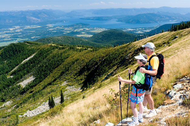
The easy stuff
The Mineral Point Trail is suitable for families.
PHOTO BY CORY MURDOCK |
|
First is Mineral Point Trail No. 82 dedicated to Brent Jake Jacobson 45 minutes from town via Sagle Road, Garfield Bay Road and then Forest Roads 2672 or 532. No. 2672 leads to Green Bay at the lower end of the trail, while No. 532 is the high road. There are campsites at Green Bay, and picnic tables and outhouses at either end of the route. The trail leads some two miles as a hiker hikes through an open ponderosa pine forest on rock ledges far above the lake, as well as darker valleys filled with grand fir, hemlock, larch and Douglas fir.
This is a great trail to start kids on, with easy and varying terrain and flora and a big, beautiful lake at one end to jump in on a hot day or toss a rock into. The trail is hikeable or bikeable (even horses are allowed) and moderately easy, with an elevation gain of about 500 feet in its length. It also offers views of the Green Monarchs and Cabinets from both above the lake and from the pebble beaches of Green Bay.
Next on the ease-o-meter is the complex of trails at Schweitzer Mountain Resort. Its no sweat to get there 25 minutes from Sandpoint on paved roads to Schweitzer Village to trailheads that offer various levels of exertion. There are miles of trails and roads of varying pitch, plus lots of single- and double-track trails for the bike minded. The resort has free trail maps, bikes and mountain scooters for rent, and a mondo elevation equalizer: The Great Escape Quad.
Schweitzer is rated second easiest because hikers dont necessarily have to walk up. The chair that takes skiers to the top of Schweitzer Peak in winter runs in the summer, too; an easy-loading-and-unloading, four-person lift that whisks you to the top in about the same time it takes to get your heart rate above 120 if you choose to hike up the mountain.
Choosing to walk provides a lot more to see up close and personal, trekking through subalpine forest, tag alder patches and meadows that are in bloom with something from the time the snow goes off nearly until it returns.
Schweitzer offers a virtual web of trails, most beginning near the bottom of the Quad. To the left, one threads up through the forest along the main stem of Schweitzer Creek and then casts back and forth under the quad on a strenuous climb that leads to the top of the mountain. To the right, the road that doubles as a return track during ski season climbs at a steady rate along the south face of the ridge topped by the Great Divide.
Also at the bottom of the quad, a large series of trails used by cross-country skiers in the winter form a network of roads and single-track through dark hemlock groves and open timber, leading out to Picnic Point or way out to Wolf Ridge.
Ride the quad to the top ($10 for an all-day pass and free for season pass holders) and take one of two loops that begin there and run north along the ridge past the top of Chair Six, known as Snow Ghost. These offer incredible views of the lake, as well as a perspective of mountains in three states and Canada.
Its possible to walk down the hill by a number of different routes a good kid adventure or ride back down on the quad. Whichever you choose will provide an ever-changing perspective of the basin below, but lunch will probably taste better if you walk.

Goat Photo by Mathew Hall |
|
Easy access but more challenging
The next hike is the original easy-to-get-to trail, Gold Hill Trail No. 3. The lower trailhead is on Bottle Bay Road, with parking and an outhouse. The trail ascends steeply up the north face of Gold Hill, switching back and forth through deep timber for the first mile and a half before leveling off and trending south and west through a basin full of birch, aspen, cedar and Douglas fir.
Theres a bench at the one-mile mark that provides a panorama of Kootenai and Oden bays and the Cabinets front, west of Pack River. From there the track continues through forest another three miles to a wide-open vista on a rock point looking down the Pend Oreille River and northwest toward Sandpoint and the Selkirks. Continue on from there another quarter of a mile to a bench on the hillside, and just past that, to Contest Mountain Road No. 2642 and the upper trailhead.
Gold Hill has a relatively steady grade interspersed with easy-walking sections. A strong hiker can make it to the rocky point in just over an hour. Mountain bikers use this trail extensively and can access it from Road No. 2642, which is not necessarily an easy climb, but its easier than pumping up the single-track. The Gold Hill Trail is a good trail for kids who are ready for something a bit more adventurous, and because of its shady north-facing terrain, its great on a summer day.
Next is the trail easiest to get to the Mickinnick Trail No. 13. The parking lot and outhouse are a little more than three miles from town on Woodland Drive. Volunteers built this trail on land donated to the Forest Service for that purpose by Mick and Nicky Pleass. From trailhead to trails end is four miles, and it is no pushover. A quarter-mile from the parking lot, it begins up and keeps climbing, rising more than 2,000 feet in its length; roughly 500 feet per mile of trail. Thats a workout, especially on a warm summer day. The east-facing aspect of the trail makes it more user-friendly in the afternoon.
The trail leads through open forest on a rocky hillside with big ponderosa pine, larch and Douglas fir trees and shady groves of cedar and white pine interspersed along rock benches where water gathers. There is a viewpoint with benches at the half-mile point, a good goal for folks with small kids or cardiovascular challenges. Beyond this, the trail dips briefly into a dark swale before beginning an unrelenting climb.
Halfway to the top is Cougar Rock, offering a tremendous view of the Purcell Trench, the lake and the Cabinets. From there, the trail trends along a magnificent rock bench full of big timber before beginning up through one shelf after another to the ridge with filtered views of the ridgetops at Schweitzer. Then, it trends southwest through deeper forest and a little swamp before ending on a rocky knob commanding a view of Sandpoint, the Long Bridge, the lake and a long arm of river stretching off toward Washington.
Not easy but worth the effort
Next is the trail hardest to get to, and nearly the hardest to climb famous Scotchman Peak Trail No. 65. The trailhead has no outhouses and not much of a parking lot. It is accessed via Highway 200, Lightning Creek Road, Mosquito Creek Road, Road Nos. 2294 and 2294A, and just within an hours drive. I dont recommend taking the Cadillac or any low-slung car to this trailhead. Horses are allowed on the trail, too, but its not recommended for mountain bikes.
This trail is also a bit over four miles, but it gains 3,700 feet, more than 900 feet per mile. The trailhead is at 3,350 feet; the top is 7,009 feet. This is not a trail to start your kids (or your hiking season) on.
Trail No. 65 begins up an old road for about three-quarters of a mile, which is the toughest part of the trip. It climbs 750 feet before the first switchback. At this point, life gets easier and the trail winds back and forth through deep forest and up an open ridgetop before popping out into spectacular bear grass meadows overlooking the mouth of the Clark Fork River and the big lake. Beyond them, Johnson Point, the Green Monarchs and Packsaddle Mountain loom. Early season, these meadows are rife with bear grass, penstemon, lupine and Indian paintbrush; so beautiful they bring tears to your eyes.
Beyond the meadows, the trail returns to forest that includes huge, wind-twisted Douglas fir. At the three-mile mark, it winds through an open forest of subalpine fir, whitebark pine and bear grass as the trail climbs toward the tree line. At the edge of the forest, huge rocks begin to appear, and soon the track takes off into the talus at the edge of a burn that happened 14 years ago. Beyond this, the trail is all rock to the top of the peak.
Scotchman Peak once held a lookout, still in evidence by decaying pieces graying in the extreme weather. The peak itself and those surrounding it are evidence of the last ice age, which less than 12,000 years ago scooped out and sculpted the Blue Creek and Lightning Creek drainages surrounding the mountain. North and west are mountains and drainages of the incredibly rugged proposed Scotchman Peaks Wilderness, much of it rock exposed by the massive forces of the glaciers.
On any of these trails, you might encounter some sort of large wildlife, an elk, deer or moose on any of them, a bear on most of them, or a mountain goat on the Scotchman Trail. Ironically, as close as it is to town, the Mickinnick is the only one of these trails on which I have seen a bear regularly, which can be a thrill. Just keep walking and make a little extra noise is my best advice unless there is a cub involved. Then, get a good grip on your dogs collar and go home.
Beyond the physical benefits of hiking these trails are the mental and spiritual paybacks; intangibles that flow into a mind and soul even as sweat flows from the body. They are opportunities to stretch yourself in dimensions beyond the three we normally live in as well as within them; and they are good preparation for other endeavors, both physical and not. Best of all, it doesnt cost a fortune in gasoline or time to indulge yourself in a good workout, a change of scenery and a meditative experience in the out-of-doors.
TRAILHEAD DIRECTIONS
Mineral Point Trail No. 82: Go south on U.S. Highway 95 to Sagle Road; turn left and travel to Garfield Bay Road and go right. At Garfield Bay, a left goes uphill across from the beach. Follow this about a quarter mile to Mineral Point Road 532; turn right and go 1.25 miles to another right onto Green Bay Campground Road 2672. This leads to Green Bay and the lower trailhead. If you wish to start at the upper end, stay on Road 532, which winds up through forest; follow signs to the upper trailhead, a half mile in.
Schweitzer Mountain Resort trails: Go north on U.S. Highway 95 to the Schweitzer Cutoff Road, then left at the light. Turn right on North Boyer and go to Schweitzer Mountain Road; turn left. Follow this paved road nine miles to the Schweitzer Village. Trail maps are available at the Mountain Activity Center in the Selkirk Lodge.
Gold Hill Trail No. 3: Go south on U.S. Highway 95 across the Long Bridge to a left on Bottle Bay Road. Follow this around Contest Point about 4.8 miles. Watch for a trail sign and a steep, paved driveway on the right. To access the upper trailhead, take Highway 95 south six miles to Sagle Road; turn left onto Sagle Road and go six miles to Contest Mountain Road 2642 (located on the left at the hairpin turn); turn left onto Road 2642 and go six miles to the trailhead.
Mickinnick Trail No. 13: From Sandpoint, take Highway 95 north 1.3 miles to Schweitzer Cutoff Road; turn left and go a half mile; turn right and go less than a mile to turn left on Schweitzer Mountain Road (at Schweitzer Sign); go one-half mile to Woodland Drive; turn left and go 0.7 miles. The trailhead parking, with pit toilet, water and map, is on the right.
Scotchman Peak Trail No. 65: Go east 25 miles on State Highway 200 to Clark Fork. In Clark Fork, turn left at Hays Chevron onto Lightning Creek Road. A half-mile after that, FR 419 goes left. Go straight ahead onto Mosquito Creek Road, and follow 1.4 miles to a right turn onto FR 2294 (watch for the sign). Continue on 2294 three-quarters of a mile to a left and then another third of a mile to a left on FR 2294A, which winds about a mile and a half to the trailhead, a total of 6.3 miles from Hwy. 200. Watch for small signs along the way pointing to Trail 65.
Contact the Sandpoint Ranger District at 263-5111 or look up www.fs.fed.us/ipnf for more details on Forest Service hikes. |
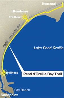
Pend dOreille Bay Trail
Dream of lakeshore park edges closer to reality
Story by Sandy Compton
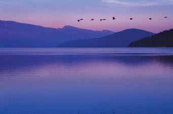
Geese on Lake Pend Oreille by DANN HALL |
|
In 1966, Sandpoint photographer Ross Hall and his high school-age son, Dann, walked along the shore curving northeast from where the city docks then thrust into the lake east of the Northern Pacific (NP) depot. They passed the water tower north of the depot and skirted the foundation remains of the Humbird mill that once pulled logs out of the huge bay between Sandpoint and Kootenai.
They came into the dense band of forest that still lines the bay – cottonwood, cedar, horsetail reeds, ferns, red-stemmed dogwood, grand fir, skunk cabbage, birch, alder and myriad other plants that love the water seeping from the clay banks rising to the flats upon which sit Sandpoint, Ponderay and Kootenai.
Somewhere on that walk, Ross told Dann that he and partner Wells McCurdy would buy the land they trod, and Dann said, “Dad! Why would you buy Bum Jungle?”
It was a good question, for, indeed, hobo camps were tucked into gullies under the trees and sunny spots facing the lake. The NP main line ran less than 100 yards away, and travelers who rode the rails found this place as attractive as many of us do now – a resting place from the travails of the world.
Ross’ answer amazed Dann even more. “This is my life insurance. This will keep your mom should I die first.” Ross suffered rheumatic fever as a young man, and no insurance company would write a policy on him.
“I couldn’t imagine anyone thinking that far ahead,” Dann said.
That piece of land still causes folks to think ahead, now about a sort of insurance policy for generations to come. The Friends of the Pend d’Oreille Bay Trail, a coalition working to build a public pathway along that same stretch of lake, hope to assure public access to the lake in an era when it is becoming increasingly rare. The group includes representatives from Bonner County; the cities of Ponderay, Kootenai and Sandpoint; Idaho Conservation League; Idaho Transportation Department; Idaho Department of Environmental Quality; North Idaho Bikeways; the U.S. Army Corps of Engineers; and individuals including the Hall family, trail advocate Leo Addison and former Sandpoint Mayor Ray Miller.
Miller began working toward a city park along this shore when he became a Sandpoint city councilman more than 20 years ago. “Once you get down there and walk that trail,” he said, “it’s like being in an alternative universe. Our idea is to preserve that environment.”
The McCurdy interest was purchased in the 1990s by the Halls, and when Miller became mayor in 2002, he and the Halls began to talk seriously about a park. Following wishes of the senior Hall, who died in 1990, the family committed themselves to seeing that the land would become accessible to the general public. In fact, they encourage people to get permission to visit their land via the Web site www.PenddOreilleBay.com, which extols the virtues of the shore and includes the Halls’ intention to make this land accessible.
Leading the Friends of Pend d’Oreille Bay Trail is Chairwoman Susan Drumheller, North Idaho associate of the Idaho Conservation League, Vice Chairwoman Jan Griffitts, Treasurer Bob Carlson (also of North Idaho Bikeways) and Secretary Marilyn Haddad.
The park they envision begins at Sandpoint’s city water treatment plant north of City Beach, which includes the Humbird ruins. Planned already for that property is a “passive” city park. The unpaved trail will begin there and dip to the shoreline before veering inland through thick forest behind a portion of the Hall property that will be retained for private use. Then, the tread will descend to the shore and follow a roadbed that has been there many years and is currently used by those who have Halls’ permission to do so.
|
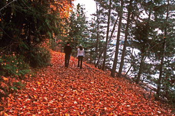
A couple walks the future shoreline trail | PHOTO BY MATHEW HALL
|
|
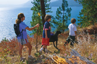
Activities the friends foresee along the trail include fishing, hiking, biking, snowshoeing, cross-country skiing, running and that Sandpoint standby – dog walking. In its ideal incarnation, the trail will run along the shore to Black Rock, a leftover from a 1910s smelter at Ponderay, then climb to the top of the bank and follow at a respectful distance the BNSF tracks to the Ponder Point community in Kootenai. Bike riders, runners and walkers will access that end of the trail via an underpass beneath the railroad, also connecting riders to a bike route back to Sandpoint via the Kootenai Cut-off Road.
Ponderay Mayor Carol Kunzeman looks forward to having the communities connected via such a trail. “Ponderay owns land at this end of the trail, which we hope becomes a park similar to the one at the Sandpoint end; a meditative place. There are still a lot of things to be worked out, but when they are, it’s going to be a beautiful place,” she said.
|
Drumheller agrees that there is a lot to do to make the Pend d’Oreille Bay Trail a reality. “This is going to take time and persistence,” she said, “but this year we would like to have some certainties in place so we can continue.”
Much work has already been done. The U.S. Army Corps of Engineers recently finished a project started more than 30 years ago, riprapping the shoreline from Black Rock to the water treatment plant near the Humbird ruins, including “wildlife ramps,” thanks to Corps employees John Coyle and Eric Winter. This summer, the Corps will replant disturbed areas along the shore with native species.
Haddad points out that there is no dedicated public access to Lake Pend Oreille between Sandpoint City Beach and Sunnyside, and it is in the interest of all the residents of Bonner County – and visitors – to do what’s necessary to build this trail.
“This is one of the last undeveloped pieces of accessible shoreline,” Griffitts said, “and it’s right in our backyard. It’s a place where people can go to renew themselves; a place to be at the lake, which belongs to everyone.”
Ross Hall, who loved to walk, might not have known in 1966 what his idea would come to, but it’s my guess that the Pend d’Oreille Bay Trail, when it’s finished, would be very much to his liking.
Look up www.pobtrail.org to learn more.
|