 |
|
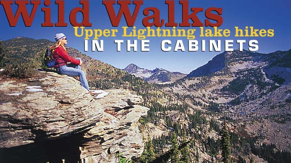
Holly Walker pauses to soak in the views while hiking in the Cabinet Mountains. Photo by Woods Wheatcroft
|
By Dennis Nicholls
“Dew glistened on every blade of grass, sparkling in the dim light of early morning. Up ahead, Lake Darling, shrouded by mists rising from its placid surface, awaited the coming day. The July dawn was as still as a sleeping baby, as quiet as a church at prayer time.
Wisps of warmer air were already stirring beneath the spruce and fir boughs shading Lightning Creek. Its icy waters sang with a hundred voices blended in harmony. I slowed my pace, wanting to absorb every nuance of the birth of a new day.
A sudden crashing in the thick woods brought my leisurely stroll to an abrupt halt, and my eyes widened in a mixture of fear and expectation. I squinted into the murky half-light beneath the black canopy. An image not 30 feet away took shape.
It was a moose studying me as intently as I studied it. I saw no antlers and knew it was a cow when the next movement materialized a few feet behind her: a calf wobbling on legs too long for its small body. Both animals stared, the mother undoubtedly debating whether to trample me into the soft earth, and the calf, perhaps, with the same curiosity for this human as humans always have for babies of any kind. I searched for a tree to shinny up in case mama moose took a sudden dislike to me. She didn’t, and across the creek they ambled and out of sight.
 |
|
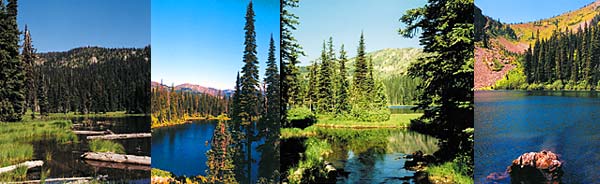
From left, lakes above Lightning Creek include Blacktail, Gem, Darling and Estelle. Photos by Dennis Nicholls
|
My footsteps up Lake Darling Trail No. 52 had more spring, and my mind reeled with delight at the surprise encounter. The final mile to the lake went quickly, and though I longed to continue beyond the tree-studded meadows bordering this alpine gem to Mount Pend Oreille, now awash in glorious sunshine, I had a different gem in mind as my next destination.
The hike to and from Lake Darling took two hours. The drive from one trailhead to the other took five minutes. I grabbed the camera, a candy bar and set off up Gem Lake Trail No. 554.
Upper Lightning Creek north of Clark Fork, Idaho, harbors four alpine lakes and the trail to a fifth. Twelve thousand years ago the climate changed and glaciers receded, leaving behind puddles of water that evolved into the exquisite jewels today called Moose Lake, Blacktail Lake, Gem Lake, Lake Darling and Lake Estelle, which nestles in a basin perched on the east side of the Pend Oreille Divide above South Callahan Creek. Collectively, these lakes form the centerpiece of a vast, wild land straddling the northwest end of the Cabinet Mountains.
From Katka Peak south of Moyie Springs, Idaho, to Scotchman Peak towering above the Clark Fork River Delta, this section of the range – the West Cabinets – offers excellent hiking, horseback riding and mountain biking.
Forests took hold on the mountainsides after the glaciers melted. It got warmer but not necessarily drier. Today the Cabinets catch much of the moisture streaming inland from the Pacific Ocean, resulting in heavy snow, lots of rain, a long growing season and fast-growing trees. Not long after the first explorers, who were fur trappers and miners, blazed trails throughout these mountains, the timber kings followed. In little over a hundred years, roads were bulldozed across the landscape and logging ruled the land.
The resilient forests renewed themselves, and the remotest enclaves of wilderness were untouched. The legacy of roads and trails in the 21st century provide superb access to places like the lakes of upper Lightning Creek.
Within a couple hundred yards, I realized the hike to Gem Lake would be more difficult than the easy saunter to Lake Darling. The trail was narrower, steeper and featured several logs posing the question, “Shall you go under or clamber over?” With my long legs, I went over and strode amidst Douglas fir, Western larch and lodgepole pine. Huckleberries added their unmistakable fruity fragrance to the clean smell of the high country.
A mile and a half and 1,400 feet in elevation from the trailhead, Gem Lake appeared through the trees, a bright blue cordial reflecting the immense sky. The trail snaked through a primitive campsite to the lake’s edge. Squeezed on all sides by a dark forest brooding beneath the strengthening sun, I scrambled through a boulder field for a better perspective of the lake’s surroundings. The panorama that unfolded lifted my heart anew in appreciation of the ice that fashioned the locket cradling this gem close to the mountain’s bosom.
Reluctantly, I departed Gem Lake. Not half of the day’s hiking was over, but the sun approached its zenith and I wanted as much daylight as possible for the other three lakes.
From Gem Lake trailhead, Road No. 1022 goes up Moose Creek to another trailhead 20 miles from Highway 200 by way of Trestle Creek Road No. 275. Lightning Creek Road No. 419 provides access as well, but East Fork Creek roared out of the Scotchmans in 1996 and took a large chunk of the road with it to the Clark Fork River. Adventurous folk in four-wheel drives attempt to ford it these days, and most make it through, but Trestle Creek is a safer route to follow.
I marched double-time on Trail No. 237 to Moose Lake, a mere two miles along a wide, pleasant trail. Voices drifting through the forest alerted me to people up ahead, and once I caught them, they advised I be on the lookout for a moose and calf. I could hardly believe it was the same cow-calf pair I saw near Lake Darling, so I rushed past them to try to catch the critters. Tracks at the lake’s edge were so fresh, water still seeped into the impressions, but the moose were nowhere to be seen. A faint trail led through sedges to a view of Moose Mountain silhouetted in the southwest sky.
 |
 |
|
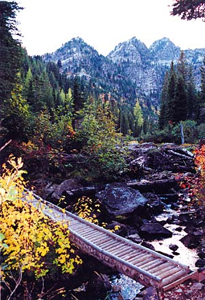
Trail to Lower Geiger Lake. Photo by Dennis Nicholls
|
|
Once the other hikers made it to the lake, I darted a half-mile back down the trail to Trail No. 36, which meanders between granite boulders and over a ridge to Lake Estelle. The Cabinets are almost entirely comprised of sedimentary rocks laid down in a shallow sea 600 million years ago. It was a surprise to see the much younger granitic intrusion surfacing on the Pend Oreille Divide.
The trail skirted past house-sized stones, then climbed to the lip of Lake Estelle. She was a beauty. I sat on a log, my brow massaged by soothing breezes playing across ripples mirroring the cliffs, timber and meadows framing the docile lake. But the sun had begun its slide to the western horizon and there was one more lake to see.
Another mile down Trail 237 brought me to Blacktail Lake Trail No. 24. This proved to be the most difficult of the five trails. Three miles of tread and hundreds of feet of boardwalk traversed the mountainside, marshy at times from dozens of small springs, into the basin at the headwaters of Deer Creek.
Boggy meadows, an avalanche zone and rock encircle this shallow lake. Conical spires of subalpine fir reflect in its clear waters. Wilderness silence embraces the basin. I eased down next to a boulder against which to rest my back and sat quietly so as not to disturb the tranquility permeating the very air I breathed.
The sun dipped below the tree line and would soon disappear behind Trestle Ridge. A soft breeze whispered I should go, but I argued for staying a moment longer. Lingering in the high country for a day, an hour, even just one extra moment is the best salve for a weary soul. Blacktail Lake glimmered beneath mists rising from its placid surface, waiting the coming night. The July evening was as still as a sleeping baby, as quiet as a church at prayer time.
Trailheads Directions:
Go 12 miles east of Sandpoint, Idaho, and turn northeast off Highway 200 onto Trestle Creek Road 275. Travel 16 miles to Lightning Creek Road 419; turn north and go a half-mile to the trailhead for Lake Darling Trail No. 52; a quarter-mile farther is a short spur road to the trailhead for Gem Lake Trail No. 554; from there it is 2 miles on Moose Creek Road 1022 to the trailhead shared by trails 237, 36 and 24. They are all well-signed.
|
Mountain Biking the West Cabinets
From Boulder Creek in the north end to the Clark Fork River in the south, literally hundreds of miles of roads and trails offer a wide range of opportunities for mountain bikers in the west Cabinet Mountains. Check with the Forest Service for more information and maps. Below are descriptions of two popular trails in this part of the Cabinets suitable for mountain bikes.
Timber Mountain Trail No. 51
Rated from easy to difficult, The Timber Mountain Trail is located southeast of Bonners Ferry in upper Boulder Creek. It follows the old roadbed from Boulder Meadows to Callahan Divide (about 5 miles), then connects to a network of trails leading to Troy, Mont., or the Pend Oreille Divide. A great loop is feasible starting and ending in Boulder Creek using Orville Heath Trail 54 and Kelly Pass Trail 155. To reach the trailhead, take County Road 24 east from Bonners Ferry for about 13 miles where it becomes Forest Road No. 314 and continue southeast on that road past its junction with Boulder Creek Road 408. Continue a mile and a half beyond that junction to the trailhead near Boulder City.
Strong Creek Trail No. 444
Rated moderately difficult, the Strong Creek Trail is one of the more popular mountain biking trails in the region. This is an old road up Strong Creek in Hope to the top of the ridge near Round Top. The Bee Top-Round Top Trail crosses this path at the summit and offers the biker several opportunities for some terrific hardcore biking either toward Trestle Creek or down the Wellington Creek Road into Lightning Creek or southeast along the ridge to Bee Top Trail No. 120. To reach the trailhead, turn north off Highway 200 onto Centennial Avenue next to Hope’s Memorial Community Center. Take a left onto the old highway and go about one-quarter mile to the Post Office. Main Street, a narrow, one-lane paved road, veers right uphill in front of the Post Office. Follow it a couple of hundred yards and take a sharp right uphill toward the cemetery; continue past the cemetery on a dirt road beyond the sign that says “Road Closed 3/4 Mile Ahead” to the trailhead.
|