Floating in the Wake of David Thompson
By Lou Springer
The rivers of North Idaho were used for at least 10,000 years by Native Americans as routes of travel, trade and visiting. David Thompson, a Welshman, was the first European to float and map these rivers as part of his grand vision to survey the huge, unknown portions of the continent.
The roar of water and the shimmering rainbow above the disappearing river were no surprise to David Thompson. Kootenai Indians upstream had told him that to reach the country of the Salish people and their untapped resource of fur-bearing animals, he would first have to get past a thunderous set of waterfalls that dashed through a narrow canyon on the Kootenai River.
Early in May 1808, this legendary entrepreneur and explorer was entering North Idaho's back door on the Kootenai River's spring run-off. Thompson, after 13 years working for Hudson's Bay Company, was now a partner in the North West Company, a Canadian fur consortium. He and six French Canadian trappers were speeding down in a birch-bark canoe from a trading post Thompson had built on the shores of Windermere Lake in British Columbia.
Crossing the sheer rock of the canyon walls, 250 feet above the spray, was a narrow animal path. It was the only possible portage. "The least slip would have been inevitable destruction," Thompson wrote that night in his daily journal, "as the steepness of the rock allowed no return; or, in once falling, to stop till precipitated into the river."
Today's traveler can absorb the beauty and power of the falls from a park bench at the end of a trail. Kootenai Falls lies 21 miles east of the Idaho-Montana border on Highway 2.
The dippers and harlequin ducks that Thompson mentioned in his journal are still seen here. The river's flow, however, is no longer determined by snowmelt alone. Upstream, the Libby Dam forms a water impoundment and controls the release of water.
Miles of beautiful river floating exist from the dam to above the falls and then below the canyon on to Bonners Ferry. The current is steady and strong with Class II rapids at the mouths of tributaries and one river-wide Class III at China Rapids.
The strong and steady current carried the Nor'westers' canoe quickly past the mouth of the Moyie River to a Kootenai Indian camp. Thompson's relations with native people were always marked with respect and honesty. He was one of the few traders who refused to traffic in alcohol. Highly regarded by tribal people, he was called Kookoosint, meaning the Stargazer.
Temperatures were high that May of 1808. The water from melting mountain snows, which had swollen the rivers, was now flooding lowlands. The Lake Indian Trail south to Lake Pend Oreille was under water, ruining Thompson's hopes of contacting the Flatheads, Kalispel and others of the Salish-speaking nations. Running out of time to transport a winter's worth of furs to company headquarters near Lake Superior, the surveyor reluctantly turned back.
Thompson realized his small canoe was inadequate for the raging Kootenai River, traded for packhorses and asked for a guide. Determined to cross overland, he turned up the Moyie River, which he describes in his May 26th journal entry as, "25-30yds wide fully, bold & deep, very strong Current."
The bold current and plentiful rapids make the Moyie a playground on a June afternoon, and it is difficult to imagine the hardships that Thompson's men and horses endured that spring as they traveled through this lovely countryside. Armed only with a two-pound axe, they cut down huge larch for bridges and watched helplessly as the rushing torrent swept them away. The legs of the horses were so badly cut by rocks that they left a trail of blood.
Reaching more level country on the 30th, Thompson finished his daily log. "We camped on the waters Edge (having had a Day of extreme Danger & hard work) I hope we have now done with this terrible River."
Nothing could daunt his adventurous spirit for long. Since 1784, his activities had defined the line of the frontier. Thompson returned to Idaho in August 1809 intending to build two trading posts and to winter with the Flatheads. With summers' lower water levels, they were able to line the canoes down Kootenai Falls and camp near the Lake Indian Trail, which connected the Kootenai and Pend Oreille Lakes. Trading for horses, they packed their trade goods south. Highway 95 now follows this Native American trail down the Purcell Trench.
On Sept. 8, his party reached Pack River. "At 7/1/4 Am set off, Co S20E 1/2M to a Brook, which we followed S40E 1/2M then crossed it, it is 15yds wide, deep & very easy current."
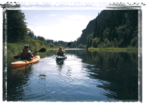
The current of Pack River is still very easy, and no finer way can be found to enjoy a sunny day than to float the lazy meanders of the brook. Pack River flows through tranquil farm land as well as moose habitat. There are several possible accesses from bridges along the county roads to vary the length of the float. Log jams and sweepers require maneuvering skill. Fine sand beaches, deep swimming holes and abundant bird life make this a fun outing.
Reaching Lake Pend Oreille, Thompson's band of trappers feasted on ducks, geese and a "crane." After building a trading post, Kullyspell House, on the peninsula near a large Native American encampment that lay at the mouth of the Clark Fork River, Thompson surveyed the surrounding countryside. Returning from a trip down the Pend Oreille River where he had been blocked by a long series of waterfalls, Thompson wrote about Priest River. "From thence at 8Am we went S70E 4 M to the River, then SE 4M 3/4 gone came to the Rivulet of 25yds wide."
This rivulet flows from Priest Lake and for 38 miles provides some of North Idaho's best white-water floating. There are numerous access points to plan short or long trips. The middle stretch of the river provides mellow rapids and kick-back time to enjoy the scenery. The upper section, containing Chipmunk Rapids (Class II), and the lower portion, holding 8-Mile Rapids (Class III), are demanding and exciting.
In early October, Thompson went up the Clark Fork River to establish Saleesh House and trade with the Flathead near the falls that bear his name. The river, long a corridor for the Salish People, became the canoe connection between the two trading posts. The two-day journey would have required expert river skills.
A section of the Clark Fork River from below Cabinet Gorge Dam to Lake Pend Oreille still offers a fine day float. The muscular current pushes through the last of the Cabinet Mountains, flows through rich bottomland and slows as it enters the delta. If the water is low, old bridge pilings appear near the present bridges and must be avoided. Beyond the third bridge, a river left turn is required to avoid the log shunt and to reach the correct channel to the Johnson Creek boat ramp.
David Thompson, in faithfully following the rivers, was also following an ancient way of travel and commerce. The rivers are wrapped around and bind landscapes together, as well as tying people together. Regardless of changing cultures and altered landscapes, the people of North Idaho will always be tied together by a network of rivers.
Lou Springer lives in Heron, Mont., and floats in Thompson's wake in her inflatable kayak.