 Above the FogAbove the Fog
by Dennis Nicholls
Copyright 1996 © Sandpoint Magazine
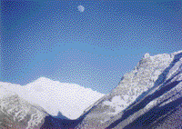
From our vantage point high on the snow-covered slopes, the gloomy mists blanketing the valley below resembled a carpet in need of cleaning. The fog and low clouds had been reason enough for Jeb and I to head for the high country. Standing among the snow ghosts sculpted by Old Man Winter's icy chisel, the urgency and responsibilities of life down below just fell off my shoulders.
A cold sun blazed in an oceanic sky. At that moment it was my life preserver, and I turned my face toward its meager warmth. In the stillness of a dazzling December afternoon, I mused that surely no ecstasy on Earth compares to that of a wintry day in the high Cabinet Mountains.
Contrary to popular opinion, the snowbound ridges and peaks of the Selkirk and Cabinet mountain ranges around Sandpoint welcome visitors in winter as well as summer. With proper gear and preparation, the physically fit outdoor enthusiast can enjoy the high country in January just as well as in July. And one worthy destination is Squaw Peak, about 35 miles east of Sandpoint in the Cabinet Mountains between Clark Fork and Noxon, Mont.
The only manned lookout tower on the Cabinet Ranger District perches atop Squaw Peak. In summer visitors will find someone there scanning the distant mountains for smoke from wildfires. In winter, visitors will find snowdrifts higher than a house.
Ridges radiate out from Squaw Peak, rimming steep-sided basins that offer telemarkers fabulous skiing opportunities. A popular feature to ski on the mountain is The Steershead, a long talus slope that resembles the head of a steer. It is clearly seen from Highway 200 soon after crossing the state line into Montana.
Squaw Peak is a relatively low summit at 6,167 feet, but its position overlooking the lower Clark Fork Valley exaggerates its elevation. Those who have conquered its rocky heights exclaim that the view is no better from any higher peak in the range. Westward are the glittering waters of Lake Pend Oreille, visible when that dirty carpet of fog has been vacuumed up by the sun.
Northward one will gaze across the quiet wilderness of the West Cabinets, also referred to as the Scotchman Peaks, where the mountains collide in some of the wildest country remaining in this region.
Eastward is the Bull River Valley and the lofty pinnacles of the main spine of the Cabinets. The entire length of the Cabinet Mountains Wilderness, crowned by the 8,738-foot massif of Snowshoe Peak, can be spied from Squaw Peak.
The fire lookout tower on Squaw Peak, formerly available for rental in winter, is now locked during the off season. Firewood is scarce on the summit, and the Forest Service says providing propane to heat the structure became too expensive. So skiers and snowshoers will need tents or to build snow caves.
To tackle Squaw Peak in the wintertime, you must be in good physical shape. None of the routes in is easy. Don't go alone. Be acutely aware of avalanche hazards and avoid all avalanche terrain. Know the symptoms and affects of hypothermia, which is one of the biggest killers in wintertime. Hypothermia often happens in winter by hard skiing that causes overheating and sweating. The best defense is to rest frequently. Dress in layers, so you can remove or add clothing as necessary to maintain an even body temperature
There's no need to settle for bouts of cabin fever during a North Idaho winter. Above the fog is a landscape teeming with adventure. ·
Dennis Nicholls is an inveterate explorer and publisher of The River Journal.
· Big Eddy Trail No. 998: This is the shortest hike and easiest access. From Sandpoint go east on Highway 200 into Montana. At mile marker 6.2, just past Forest Road 2292, is a narrow dirt track ascending steeply from the highway. Park in a nearby turnout, then follow the old road to the trail. Elevation gain of nearly 4,000 feet; 8 miles roundtrip.
· Pillick Ridge Trail No. 1036: Between mileposts 10 and 11 on Highway 200 turn north on Highway 56. Go about 7.5 miles and watch for the trail sign. Follow an old logging road to the trail. Elevation gain of 3,800 feet; nearly 25 miles roundtrip.
· Star Gulch Trail No. 1016: Continue north on Highway 56 to milepost 13, and turn onto Forest Road 1118, Dry Creek Road; the consolidated trailhead is less than a half mile off the highway. Elevation gain of 3,800 feet; about 16 miles roundtrip.
For maps and more information contact the Cabinet Ranger Station, 2693 Highway 200, Trout Creek, MT 59874, or call 406/827-3533.