|
|

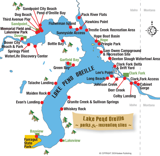
Lake Pend Oreille: Parks and Public Access Sites
By Jane Fritz & Dennis Nicholls, excerpted from the book "Wilderness of Water: Legendary Lake Pend Oreille."
Lake Pend Oreille has plenty of parks, boat launches, picnic sites and other attractions and facilities. Here is a guide to public parks and public access sites on Lake Pend Oreille, starting with the south arm of the lake and moving north, then going sideways west to Dover, back to Sandpoint and then east around the lake, including up the Clark Fork to Cabinet Gorge. You can click on the park name on the map at right to jump to its description below.
Farragut State Park
This is a fee area managed by State of Idaho Parks and Recreation.
What’s it like?
It was named for Admiral David Farragut, the first Navy admiral appointed by Congress for leadership during the Civil War, who was known for his famous cry of “Damn the torpedoes! Full steam ahead!” This once-expansive, inland U.S. naval base was the second-largest naval training facility in the world. Farragut was integral to the nation’s World War II effort, having trained almost 300,000 sailors.
Acquired by the state in 1965, today Farragut is one of the premier state parks in Idaho. It encompasses 4,000 acres of pine forests, open meadows and spectacular sandy beaches and lakefront. Besides being one of the largest camping areas in northern Idaho, it offers facilities for a variety of year-round recreational opportunities and is a popular cross-country skiing area in the winter. Year-round attractions include a visitor center, the Brig Museum, which tells its Naval history, and an interpretive walking tour of the park. Part of the park is co-owned by Idaho Fish and Game and is managed as a wildlife refuge. Farragut Park has hosted National Girl Scout and Boy Scout Jamborees over the years, giving more than 130,000 scouts the experience of a lifetime.
Boaters, sailors and paddlers enjoy Farragut because of its sheltered location on the lake. The high, steep cliffs tumbling off Bernard Peak protect the two bays – Scenic and Idlewilde – that anchor the south end of Lake Pend Oreille. Eagle Boat Landing is a large, modern facility that accommodates most types of marine vessels. It is located just south of Blackwell Point on the west side of Idlewilde Bay.
Hiking, bicycling and mountain biking opportunities in the park are extensive, ranging from easy excursions of less than a mile to all-day adventures of 20 miles or more. Detailed maps are recommended and available for purchase at the park visitor center. The most popular trails include: Squirrel Cache Nature Trail – a self-guided interpretive trail (a portion of the trail was originally a horse and wagon route in the 1860s); Shoreline Trail that winds along the shoreline from the Blackwell Point Viewpoint south to Eagle Boat Landing, past Beaver Bay Swimming Area, around Buttonhook Bay, and then upland through a pleasant forest environment where it joins the Highpoint Trail – a three-mile trail that affords hikers a variety of options and terrain including spectacular vistas of the lake. Beaver Bay is one of the nicest areas for swimming on the lake.
Horseback riders and llama users are also welcome at Farragut but are restricted to the trails north of Highway 54. The newly developed Corral Area provides equestrians and llama users easy access to these trails, which are also accessible to hikers and bikers. The Corral Area, located just north of the Thimbleberry Group Area and east of park headquarters, is made up of two public access areas of temporary holding stalls. Here you’ll find ample parking, overnight campsites, hitching posts and a watering trough. But beware if your horse spooks at loud noises: The park’s shooting range is also in this area. Future plans for this area include a basic riding arena, shelter, equestrian experience course and improved trail linkage.
The Sunrise and Willow day use areas at Farragut offer picnic shelters, tables and lakeview cabins that can be reserved for gatherings and events. The Willow Day Use Area also has coin-operated spotting scopes for viewing mountain goats on the Bernard Peak cliffs across Idlewilde Bay.
Farragut State Park offers lots of camping choices. There are nearly 200 overnight sites at five campgrounds, plus two group camp areas. Overnight fees vary, and trailers and RVs up to 32-feet long can be accommodated. Campgrounds offer boat ramps, docks, dump stations, flush toilets, hot showers and potable water. For reservations, call 208-683-2425 or log onto www.reserveamerica.com.
At the western end of the park, just past the visitor center, is a large, open area for flying model airplanes. One of the newest attractions at Farragut, an 18-hole disc golf course is located at the east end of the park near the Locust Grove Picnic Area and water tower. The course offers hours of challenging fun in a forest of mixed-age trees. Keep a close eye on your flying disc, though, as it is easy to lose in the summer foliage.
Farragut State Park is one of the best places in northern Idaho for family-centered outdoor adventure. Come for an afternoon picnic and swim, or camp for several days and explore the surroundings. For more information about this park, go online to www.idahoparks.org and search for Farragut.
FACILITIES: concrete boat ramp, docks, fish-cleaning station, group picnic areas, group and individual campgrounds, amphitheater, picnic tables, restrooms, hot showers, dump station, RV hookups, sandy beach, horseshoe pits, volleyball courts, drinking water; hiking, horseback and biking trails; photographic viewpoints, coin-operated spotting scopes, shooting range, model aircraft field, disc golf course, visitor center and Brig Museum
ACTIVITIES: camping, boating, sailing, canoeing, kayaking, scuba diving, fishing, swimming, picnicking, hiking, biking, horseback riding, wildlife viewing, horseshoe and volleyball games, model aircraft flying, target shooting, disc golf, and museum tour
How to get here:
From Athol on U.S. Highway 95, turn west on Idaho State Highway 54 and travel four miles to the main entrance just past the traffic circle. The visitor center is on your right and has maps, campground information and interactive displays about the wildlife and geology of the park. Farragut State Park is open year-round.
Bayview
A free, public boat launching facility managed by Kootenai County occupies a narrow slot leading to the water in the center of Bayview, next to Boileau’s Resort.
What’s it like?
Located on Scenic Bay next door to Farragut State Park, this is the gateway for Lake Pend Oreille for those approaching from the Spokane-Coeur d’Alene area. In fact it was Spokane entrepreneurs who built it as a resort community, welcoming its first permanent residents in 1910. There are numerous private marinas, restaurants, shops and other amenities available, including marine tours and charters. Private property crowds this launch site and parking is limited.
Bayview also has something familiar to visitors from the Puget Sound area – old limestone kilns. A cement industry flourished in the area in the early decades of the 20th century, and lime was shipped first by barge north to railheads at Hope and Sandpoint, and then directly by rail to Spokane. You can view the ruins of the kilns from Scenic Bay Marina.
This lakeside community is home to hundreds of sailboats, and you’ll see a lot of float homes and houseboats moored in the marinas, too. They have been a part of the Bayview experience for generations. This is one of the most popular boating and sailing areas on the lake.
The residents of Bayview host a major annual event that draws crowds of tourists from around the region – Bayview Daze. It’s a community celebration that happens around July Fourth and culminates in a spectacular fireworks display over the water.
The U.S. Navy has maintained an acoustic research facility in Bayview since the 1950s, including work on the Sea Wolf submarine. One-fifth scale models of the Navy’s equipment are tested on Lake Pend Oreille, but the newest facet of the Navy’s research is surface water warfare testing with a 133-foot, quarter-scale model of a destroyer that launched in 2005. The Sea Jet operates on the lake between Bayview and Garfield Bay.
FACILITIES: concrete boat ramp; public dock; gas, rope crane, marine supplies and repair at private marinas; sailboat, fishing boat, houseboat and canoe rentals and moorage; boat cruises, tours and charters; restaurants, groceries, retail shops and lodging
ACTIVITIES: sailing, boating, paddling, fishing, houseboat camping, picnicking, wildlife viewing, scuba diving
How to get here:
Take Idaho State Highway 54 east from U.S. Highway 95 at Athol and travel six miles, passing through Farragut State Park to reach Bayview at the northeast corner of the park.
Lakeview
This area offers free public facilities managed by Bonner County. Tying boats up overnight on docks is OK if not near the gravel launch, but picnicking on docks is not allowed.
What’s it like?
Flanked by private property, the small community of Lakeview is surrounded by abandoned limestone mines. It is a serene and pleasant place, and surprisingly much of the town is situated on a bench well above the lake with the majority of houses lacking a view of the lake. Three miles above Lakeview is the Happy Hermit Resort that operates year-round, catering to snowmobile enthusiasts in the winter. There are numerous small beaches from here to Whiskey Rock.
FACILITIES: gravel boat ramp, docks, sandy beach, vault toilet
ACTIVITIES: boating, fishing, swimming, scuba diving
How to get here:
Follow the Bunco Road No. 332 just over seven miles east to where the pavement ends at a large parking area. From there the road climbs into the mountains south of the lake. Drive another six miles to the junction with Road No. 278, which descends from Road 332. From there, it’s approximately 12 miles to Lakeview. The narrow road down to the lakeshore is steep and rutted. There is parking for only three or four vehicles. See "Lake Drives."
Whiskey Rock
Managed by the U.S. Forest Service, this is a no fee area that has 13 campground sites accessible to small motor homes and travel trailers. Campground limit is 14 days.
What’s it like?
Shaded by big ponderosa pines and Douglas firs, this remote site is a great destination on the lake’s eastern side. The rocky shoreline makes for some interesting exploration along the edge of the lake, while a pleasant grassy area adjoins the beach. It is a picturesque, wooded cove with sweeping views of the lake and its western shores. There is a dock here for boats arriving by water, but there is no public launch ramp. The primitive launch site here is private for use only by Whiskey Rock residents. Car-top boats can access the lake from the gravel beach.
FACILITIES: campground (no electrical hookups or large RVs), drinking water, telephone, dock, picnic tables, vault toilets, gravel beach
ACTIVITIES: camping, picnicking, boating, fishing, swimming, scuba diving
How to get here:
Road access is from Johnson Creek-Lakeview Road No. 278. The access dirt road to the boat ramp is narrow and rough; large RVs are not recommended because there is only a small turnaround. An approach from the water across the lake at Garfield Bay or from Bayview is the better idea. See "Lake Drives." It is also accessible by hiking down Packsaddle Mountain Trail No. 76.
Granite Creek and Sullivan Springs
The fish weir at Sullivan Springs is maintained by Idaho Fish and Game for kokanee reproduction. The dock is managed by Bonner County as a day-use, no-fee area, but tying up to the dock overnight is allowed.
What’s it like?
Mining claims were established here during the 1880s, and a small community sprang up as a result. Today Granite Creek ranks as the most valuable spawning stream on Lake Pend Oreille for several species of fish, especially kokanee. Sullivan Springs is a magnificent, natural spring upstream from the lake about one-half mile. Granite Creek is accessed by water. In late autumn, bald eagles dot the trees along the shoreline and feed on fish that spawn and die.
FACILITIES: dock, porta-potty
ACTIVITIES: boating, swimming, fishing, scuba diving, wildlife viewing
Evan’s Landing
Managed by the U.S. Forest Service, this is a no-fee area.
What’s it like?
Primitive and remote, this site caters to hikers and boaters and is accessible only by foot or boat. It is a popular area for paddlers kayaking or canoeing south from Talache Landing. Hiking in is along Evan’s Landing Trail No. 64. Sweeping views across the lake toward the Coeur d’Alene Mountains are unmatched from this beach, and the area is often overlooked, especially on busy summer days. The remains of an old cabin are found here.
Between Evan’s Landing and Cape Horn is a narrow bench of land below the Three Sisters Peaks called Grasshopper Point. By some accounts, the lake is well over 1,200 feet deep just offshore. The U.S. Navy maintains an offshore barge just north of here, which is off-limits to the public.
FACILITIES: rustic, primitive campsites (spring until late fall), pebble beach, picnic tables, porta-potty
ACTIVITIES: camping, picnicking, boating, fishing, swimming, hiking, scuba diving, kayaking, canoeing
How to get here:
About 17 miles south of Sandpoint, Idaho, near milepost 457 turn east onto Blacktail Road (Blacktail Road makes a loop and joins Highway 95 near milepost 457 and near milepost 463). Go 2.6 miles to Little Blacktail Road, turn east again and go another 2.6 miles past one trail sign to East Ridge Road where a second trail sign indicates the way to this trailhead. Take a right on East Ridge Road, go 1/2 mile and turn left onto a short spur road. Proceed to a parking area where the road splits. It will accommodate five to 10 vehicles. The Evan’s Landing Trail No. 64 is a moderate, 2-mile hike one-way.
Maiden Rock
Managed by the U.S. Forest Service, this is a day-use, no-fee area.
What’s it like?
A primitive and remote site, it is accessible only by trail or boat. The area is adjacent to a unique geologic feature on the lake – Maiden Rock, a huge outcropping that drops steeply into the lake next to a beautiful pebble beach. A jagged ridge tumbles from the summit of Blacktail Mountain into the cold waters of the lake near the mouth of Maiden Creek. The last drop-off of several hundred feet is along the angular, stair-step cliffs.
FACILITIES: picnic tables, fire pit, stony beach, vault toilet
ACTIVITIES: boating, picnicking, fishing, swimming, scuba diving, hiking
How to get here:
From Sandpoint, Idaho, take U.S. Highway 95 south approximately 11 miles to milepost 463. Turn east onto Blacktail Road, which rises at a sharp angle from the highway across from Tri Con Bolt Company (Blacktail Road makes a loop and joins Highway 95 near milepost 457 and near milepost 463). Go 1.5 miles to Butler Creek Road No. 230. Turn left and travel three miles to the trailhead. The parking area will accommodate three to six vehicles. This is a rough and rutted road passing through private property. Maiden Creek Trail No. 321 is a moderate, 2-mile hike one-way.
Talache Landing (Talache Beach)
At the end of Talache Road, a road maintained by Bonner County, is an area that provides a day-use beachfront called Talache Landing. There is limited parking for one or two vehicles along the road. Note that this spot is actually on private property. Forest Service land is north and south of this area.
What’s it like?
This is a popular put-in area for kayakers and canoeists coming from Sandpoint and Sagle. From the water, it’s a short paddle to reach Forest Service public lakefront north of Mirror Creek (the original landing from which iron ore was shipped by barge) or south of Talache Beach, towards Maiden Rock and past several homes. It is also a convenient put-in for those paddlers who would like to try primitive camping on one of the colorful pebble public beaches in either direction. On hot summer days, Talache Beach is also a popular swimming area for local residents and scuba divers in search of treasures from mining days.
FACILITIES: mixed rocky, gravel and sand beach, convenient put-in from shore for paddlecraft
ACTIVITIES: canoeing, kayaking, fishing, swimming, scuba diving
How to get here:
There is paved access from U.S. Highway 95, five miles south of Sandpoint at the community of Sagle. Turn east on Sagle Road and drive just over a mile. After passing South Sagle Road, go right at a fork on Talache Road, which is a paved road for a ways. Travel about six miles to the end of the road.
Garfield Bay
The recreation site is managed by Bonner County and is a free day-use area, but there are fees for the campground. There are private marinas, campgrounds, lodging, stores and restaurants found here as well.
What’s it like?
When you come driving into Garfield Bay on a sunny summer day, it feels like you are descending into a small fishing village on a seacoast that time has forgotten. The open cove with its marina, boats and rustic homes offer a delightful repose. The modern campground facilities and adjacent beaches, tucked back and protected at the head of the bay with its pleasant green lawn, make it an ideal family destination with plenty of space for relaxing and playing. It is open year-round. The private marina offers boat slips to rent by the hour or day if you come to have dinner or to stay for a few hours to fish or swim. Looking back from the water, Grouse Mountain is to the west and the next landform south is Grouse Mountain Point before Talache Landing.
Garfield Bay is also a well-protected bay for canoeing or kayaking, although as you round the point toward Green Bay it can get choppy. The shoreline is rocky, but there are some nice stony beaches to enjoy swimming and picnicking. Launching from Garfield Bay it is a one- to three-mile one-way paddle to Green Bay depending on where along the shoreline you land.
FACILITIES: campground for tents and trailers (up to 22 feet with no hookups), concrete boat ramp, docks, sandy beaches, picnic tables and barbecues, children’s playground, drinking water, vault toilet
ACTIVITIES: camping, boating, sailing, swimming, picnicking, paddling, fishing
How to get here:
There is paved access from U.S. Highway 95, five miles south of Sandpoint at the community of Sagle. Turn east on Sagle Road and go 7.2 miles to Garfield Bay Road. Veer right and travel 1.25 miles to the paved parking area. The campground is across the road and is RV-accessible.
Green Bay

Photo source: Lublyou
Managed by the U.S. Forest Service, this is a no-fee area.
What’s it like?
Though it faces due south into strong winds that often blow up the length of the lake, this is one of the more beautiful places on Lake Pend Oreille’s shore. The water is exceptionally clear and rock outcroppings punctuate the shoreline. Long Point and Mineral Point are landforms on the eastern edge of Green Bay. The entire region – with its lakeside access, cliffs, picturesque shoreline, superb hiking and biking trails, and a sense of solitude even when it’s crowded, make this place a true favorite for locals and visitors alike.
The high bluffs of the Mineral Point Trail overlooking Green Bay offer marvelous views of Lake Pend Oreille. Along the trail is a memorial plaque dedicated to the memory of Brent “Jake” Jacobson, a Forest Service law enforcement officer who gave his life in the line of duty.
Despite the steep access road, Green Bay is worth the extra effort. Spending a few nights camping among the pines near the lakeshore and counting the stars at night, and fishing, hiking or just relaxing during the day is an experience every northern Idaho visitor should have, anytime between snow thaw in spring until late fall. For sailors there are temporary mooring buoys just a little ways off shore.
FACILITIES: rustic campsites, picnic tables, barbecue grills, pebble beaches, vault toilets, self-guided interpretative trail, hiking/biking trails, mooring buoys
ACTIVITIES: camping, boating, sailing, swimming, picnicking, hiking, biking, fishing, paddling from Garfield Bay
How to get here:
The campground is 16 miles southeast from Sandpoint. From U.S. Highway 95, five miles south of Sandpoint, turn east on Sagle Road and travel 7.2 miles to Garfield Bay Road. Once you reach Garfield Bay, proceed past the county recreation site to the Garfield Bay Cutoff Road. Take it 0.2 mile and turn right on Green Bay Road, then go 1.2 miles to a fork in the road. Go right and descend to Green Bay parking area. This site is also accessible by boat, but there are no docks – only mooring buoys.
Bottle Bay
There are only private beachfront homes and residential lots along the lakeshore northeast from Sandpoint, but there is one privately owned facility whose amenities are available to the public – Bottle Bay Resort and Marina.
What’s it like?
Bottle Bay is a long, bottle-shaped bay that still has many of the lake cabins that were built back in the days of commercial whitefish and kokanee fishing. On the west lip of the bay is Sourdough Point, a private residential area that used to be a winter settlement of fishermen who toughed out the harsh, cold months surviving on sourdough bread and smoked fish. The Bottle Bay Resort and Marina, built by then-commercial fish-processor Bill Zinter, still offers several amenities to the public for year-round enjoyment. Many boaters come from Sandpoint, moor up long enough to enjoy a rainbow trout dinner or glass of wine at the resort’s fine restaurant and lounge, and then cruise back to town. Some folks spend the night, a close-to-home getaway.
FACILITIES: boat launch for resort patrons, overnight (for fee) moorage, sandy beach, docks, full-service restaurant and lounge, vacation cabin rentals, kayak and canoe rentals, boat fuel
ACTIVITIES: lodging, boating, sailing, fishing, paddling, swimming, scuba diving
How to get here:
About a mile south of Sandpoint’s Long Bridge, turn east at Bottle Bay Road and follow for 11 miles. Look for resort signs on paved road, turn left and down steep hill to water’s edge. The resort is also accessible by boat.
WaterLife Discovery Center
A cooperative project of Idaho Fish and Game, the Idaho Fish and Wildlife Foundation and the local community, which includes several sportsmen groups, this habitat education and interpretive area on the southern bank of the Pend Oreille River is a grassroots work-in-progress that began taking shape in the mid-1990s.
What’s it like?
This self-guided educational center encompasses the historic Sandpoint Fish Hatchery, built in 1909, which is still used as a summer redistribution facility for rainbow trout. An interpretive center for the site features an indoor classroom and interactive exhibits for teaching about the health of aquatic ecosystems. This educational center aims to connect students and families with the natural world and their roles in it. In addition to the opportunity to learn about the fish and aquatic species of the Pend Oreille River and its tributaries, this area is also an opportunity to learn about other creatures who make their homes here – white-tailed deer, moose, muskrat, mink, river otters, bald eagles, ospreys and many species of waterfowl, woodpeckers and songbirds.
Construction and remodeling of the historic building began in 2003. Currently the property consists of 3.5 acres of developed interpretive exhibits and 6.5 acres of forested wetland with trails, benches and interpretative signs. The riparian trail meanders through wetlands, a cedar grove and mature forest habitat. On the river itself, there is a boat dock for visitors coming by water.
The WaterLife Discovery Center eventually will include overlook bridges, wildlife viewing platforms, underwater fish-viewing windows, and a wetland pond to house native threatened bull trout. There will be information on how to identify the many species of fish and waterfowl in the Pend Oreille region, as well as local plants, and exhibits about insects that tell how bugs are studied as indicators of stream health. One of the local volunteers wants to feature amphibians and reptiles. The center, in its various stages of completion, is a perfect place for teachers to bring students and parents to bring children for an informative tour of natural habitats and processes to help understand how lifestyle choices can affect the world around us. It is also a place to showcase the North American Wildlife Conservation Model, which has shaped the way wildlife is managed and enjoyed on this continent.
FACILITIES: boat dock, boardwalk, benches, interpretive signs, hiking trails, picnic tables, large parking area for RVs and buses
ACTIVITIES: boating, hiking, fish and wildlife viewing
How to get here:
Turn west on Lakeshore Drive at the south end of the Long Bridge from Sandpoint on Highway 95. The WaterLife Discovery Center is 1.5 miles from the highway and is located on the south bank of the Pend Oreille River at the mouth of a small stream.
Springy Point
Managed by the U.S. Army Corps of Engineers, this is a large, modern campground open between mid-May and early-October. There is a fee for overnight camping and campsite use is limited to 14 days. Reservations are recommended, especially for July and August; phone 877-444-6777 or visit www.recreation.gov to reserve your campsite.
What’s it like?
A quiet cove protected by a spit of sand provides excellent swimming and beachcombing. The river is downhill from Lakeshore Drive, and the mature woods are peppered with dozens of good campsites. The picnic area is down near the ample stretch of beach. People in kayaks and canoes sometimes put in here and paddle across the river to Dover or east and west along the southern riverbank. This spot is often crowded with summer visitors.
FACILITIES: concrete boat ramps, dock, swimming area and sandy beach, picnic area with tables, 40 non-electric and pull-through campsites for RVs up to 32-feet-long, toilets, showers, potable water, large parking area, dump station
ACTIVITIES: camping, boating, paddling, fishing, swimming, picnicking, wildlife viewing, bird-watching
How to get here:
Turn west on Lakeshore Drive at the south end of the Long Bridge from Sandpoint on Highway 95. Follow Lakeshore Drive three miles to the Springy Point Campground.
Dover City Beach and Park
Managed by the City of Dover, this is a day-use, no-fee area that is adjacent to the new Dover Bay waterfront community and to the west of its marina.
What’s it like?
Rocky Point is a rugged spit of land at the eastern edge of this area and Tank Hill is the small, hump-like hill that rises along the shore at Dover Point. Much of the inland area here is wetlands. In 2005, building began on the Dover Bay residential waterfront community that transformed the old mill site, 285 acres and over a mile of shoreline, into a major development with a 274-slip marina, hundreds of homesites, condos, bungalows for vacation rental, common open space, boardwalk, a waterfront village area with a café, market and fitness center, and nine miles of paved trails that connect to the Sandpoint-Dover Community Trail.
The public access area is the Dover City Beach and Park, sandwiched by the resort and located west of the marina at the end of a narrow sandy stretch of land next to Brown’s Bay Inlet. The public can moor at the marina for access to the resort’s restaurant and shops. Boat gas is available at the Dover Bay marina dock as are canoe and kayak rentals. The Dover Bay resort set aside Verwolf Vista Park at the top of Tank Hill and maintains a public hiking trail leading to it. The Balto Dog Park opened in 2009 and features a boardwalk for diving dogs, fire hydrants and a wash-down area with a solar-heated hose system.
FACILITIES: dock, picnic tables, benches, sandy beach, paved bike trails, restrooms, dog park
ACTIVITIES: boating, swimming, paddling, picnicking, fishing, walking, biking
How to get here:
Dover is three and a half miles west of downtown Sandpoint along U.S. Highway 2. Turn south at the Dover Bay turnoff, go west past the Discovery Center on Railroad Avenue to Dover Bay Way and turn left. Follow to Lakeshore Drive and turn right. Dover City Beach and Park is at end of this road next to City Hall.
War Memorial Field and Lakeview Park
Bonner County manages the boat launch and docks, and the adjacent park is maintained by the City of Sandpoint. Both are day-use only, with no fees. But the field is also home to nighttime athletic activities – baseball and football – for Sandpoint High School’s “Bulldogs” and also to the evening concerts produced by the Festival at Sandpoint every August.
What’s it like?
This is one of Sandpoint’s most popular public areas. The ample parking lot to the east of the ball field is typically crowded with cars and boat trailers all summer long. The boat launch that extends from there is paved and there are two docks for boats. Kayakers and canoeists sometimes put in here and paddle downstream to Dover, but this is a busy powerboat area, so be aware. There’s a gravel bike and walking path along the riverbank that takes you to Lakeview Park and the arboretum. A covered picnic area near the boat launch has two tables. A recent upgrading to the boat launch area in 2008 includes placement of benches along the bank.
But the most meaningful upgrade to the Memorial Field boat launch deserves special recognition. It is a project that was spearheaded by the late Gary Parker that brought together several government agencies and conservation groups. Gary’s vision was to protect Lake Pend Oreille’s water quality in a two-fold way. First, runoff from the concrete boat ramp and adjacent parking lot was diverted into a series of adjacent swales inoculated with a fungus that organically digests water pollutants such as oil and gasoline, rendering them harmless. Second, more than 650 riparian plants and shrubs, many of them native to our area, were planted along 500 feet of riverbank to demonstrate the importance of a vegetative buffer from the water – a great ecological improvement over a grass lawn that usually requires chemical fertilizers and herbicides to keep it green. Gary’s contribution to our lake will be a model of sustainable resource management throughout the region for many generations to come.
To the west of the ball field bleachers is Lakeview Park, the Native Plant Arboretum and Bonner County Historical Museum. There are tennis courts and several picnic tables, covered group shelter and a large grassy area beneath towering ponderosa pines to enjoy several family activities. Consider a game of catch, frisbee or tag – fun! Paths through the park are paved, making it easy for moms with strollers or for kids on bikes. The Bonner County Historical Museum is located on the park grounds – just look for the train caboose or large waterwheel out in front of the building. The Kinnikinnick Chapter of the Idaho Native Plant Society manages the arboretum surrounding the museum, which is a good place to learn about the native flora of the countryside surrounding Lake Pend Oreille. There are also several pairs of nesting osprey in this area, and it is thrilling to watch an adult bird spear a large fish with its talons and bring it back to the nest to feed the fledglings.
FACILITIES: concrete boat ramp, two docks, covered picnic tables, benches, gravel and paved paths, tennis courts, basketball court, playground, group shelter, restrooms, arboretum, and museum and gift shop
ACTIVITIES: boating, picnicking, fishing, biking, walking, historical tours, wildlife viewing, and learning about native flora and trees
How to get here:
The parking areas, boat launch area, and park and museum is accessed from town via Boyer Avenue (runs north and south) or Ontario Street (runs east and west), both accessible from U.S. Highway 2 in Sandpoint. There is ample parking for cars including those with boat trailers to the east of Memorial Field. Another parking lot is located on the west end of the park at the museum and arboretum grounds. It is accessed from Ella Avenue off of Ontario Street. Additional parking is along residential streets.
Third Avenue Pier
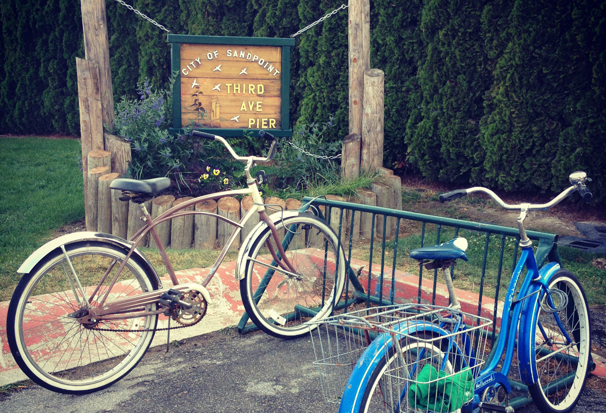
Photo source: Lublyou
Managed by the City of Sandpoint, this is a day-use, no-fee area. Hours are from 9 a.m. until 9 p.m.
What’s it like?
This out-of-the-way spot is a great neighborhood place to take a dip on a hot summer day or for anglers to drop a line in the water. At night it is so very pleasant to sit on the dock alone or with a friend and gaze at the moon. It is a very small park nestled in one of Sandpoint’s main residential sections and is worth seeking out since it is only a few blocks from downtown’s bustling main street – First Avenue.
FACILITIES: dock, picnic table, benches, small sandy beach
ACTIVITIES: swimming, picnicking, fishing
How to get here:
From Pine Street in Sandpoint, turn south on Third Street until you get to the lake. Parking is limited since it is along residential streets. Walking here or biking is easy from downtown, so you might consider leaving your car there and enjoy a stroll or ride.
Dog Beach
Found on railroad and Idaho Transportation Department right-of-way as well as private land, this is a day-use, no-fee area.
What’s it like?
Despite being sandwiched between U.S. Highway 95 and the railroad trestle, this site with good shade trees offers respite from the hot summer sun and a sandy beach. Dog Beach gets its name from the fact that this is a public beach that people can legally bring their unleashed dogs for play and a swim. Despite all the canine visitors, the area is surprisingly clean. The Sagle-to-Sandpoint Community Trail passes by the beach: to the north downtown Sandpoint is just a short distance; to the south the paved trail parallels the vehicular, two-mile span of the Long Bridge crossing Lake Pend Oreille.
FACILITIES: sandy beach, park benches, walking/ biking/rollerblading paved trail
ACTIVITIES: swimming (for people and dogs), picnicking, walking, biking
How to get here:
A gravel parking area on the north end of the Long Bridge in Sandpoint provides access to the paved community trail. Follow the trail several hundred yards south to the beach. A major highway reconstruction project is under way, which affects the northern end of the Long Bridge into town. Construction is expected to last until 2012. Access to Dog Beach will be maintained; however, keep in mind you’ll be going through a construction area, so please use caution as you and your best friend go to the beach.
Sandpoint City Beach
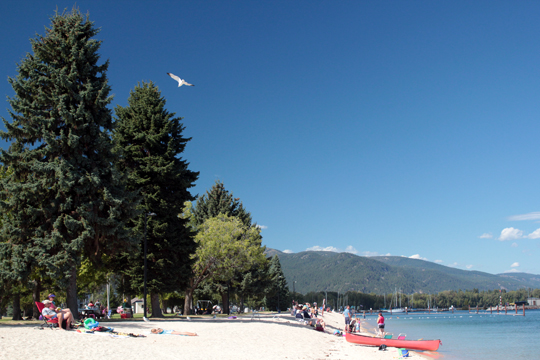
Photo source: Lublyou
Managed by the City of Sandpoint, this is a day use area only, with no fee for public access.
What’s it like?
This is the quintessential recreational site on Lake Pend Oreille. It covers 6 acres of grassy lawn and sandy beach and boasts all of the amenities associated with playing at the water’s edge.
Two marinas – Sandpoint Marina and The Windbag – straddle City Beach public docks and offer additional boat-slip moorings for powerboats and sailboats respectively. Gas is available at Sandpoint Marina, which is located at the mouth of Sand Creek at The Old Power House building. The Windbag Marina, caters to sailors and windsurfers. It is accessed by turning north of City Beach on Railroad Avenue, past the Best Western Edgewater Resort and down the gravel road and rock jetty that leads to a city water building, which is also a great place to fish for bass.
The center of Sandpoint is only two blocks away across the bridge over Sand Creek where there are shops, inns, art galleries, the Panida Theater, Cedar Street Bridge and many fine restaurants.
Sandpoint City Beach historically was a traditional Kalispel Indian village called Qp Qepe, then a site for saloons and tar paper shacks in the 1890s, and later a railway center – called the “Railroad Funnel” because of the three main lines established here by railroad agent and town father, L.D. Farmin. Today the shoreline north of City Beach and the Windbag Marina is home to a multimillion-dollar condominium resort called The Seasons at Sandpoint.
City Beach is also the site of the Pend Oreille Arts Council’s annual summertime activity, the Arts & Crafts Fair held in mid-August, a two-day event free to the public that showcases more than 100 booths of original, handmade artwork from artisans across the West. There are also kids’ arts activities, entertainment, artist demonstrations and food booths.
Also at City Beach is a miniature replica of the Statue of Liberty at the end of a concrete pier and a Peace Pillar with greetings in several languages at the end of the paved walkway on the north side of the park.
FACILITIES: concrete boat ramp, docks including the city-owned Windbag Marina, public parking, paved walkways (wheelchair accessible), sandy beaches, roped swimming area with lifeguards (summer only), picnic tables, group shelter, barbecue grills, restrooms, park benches, large grassy lawn, children’s playground, volleyball, tennis and basketball courts, horseshoe pits and a seasonal concession stand
ACTIVITIES: boating, sailing, paddling, swimming, picnicking, volleyball, basketball, tennis, horseshoes, family and group creative fun (use your imagination!)
How to get here:
Turn right off First Avenue (a one-way street going north) onto Bridge Street, then cross over Sand Creek and go under the railroad bridge until you reach the spacious, looped public parking area. If traveling south through downtown Sandpoint, you’ll have to go as far south as Pine Street (a one-way street going east) and circle around to First Avenue and head north again until the next right on Bridge Street. Getting here by bike or foot is easier.
Pend d’Oreille Bay
What’s it like?
The original French spelling of the lake’s name is used on this bay. A large sweep of city property and privately owned, undeveloped shoreline beyond the Seasons at Sandpoint private residential resort parallels the railroad tracks to Ponder Point. The trail skirts the Elks Golf Course on the east side of railroad tracks and passes through undeveloped private property and land owned by both Sandpoint and Ponderay. From shore, Pend d’Oreille Bay affords one of the most spectacular views from Sandpoint across the lake towards the Cabinet Mountains. A proposed two-mile public waterfront trail is under development. To learn more, visit www.pobtrail.com. The bay itself is popular with paddlers and sailors.
How to get here:
Take Bridge Street in downtown Sandpoint across Sand Creek and under the railroad viaduct. Turn left at the motel before City Beach, go past the Seasons at Sandpoint to the end of the road, and past the city water plant. Park here along the road. Formal permission to use the existing private, waterfront trail is necessary and available on an annual basis by calling (866) 877-3995 or submitting a form under the “Invitation” tab at www.penddoreillebay.com. Please respect the privilege of using it by leaving it better than you found it.
Fisherman Island
What’s it like?
Off the western shore of Sunnyside, this small island was once popular with fishermen who went there for bull trout and char. Idaho Fish and Game manages this rustic site for day use only. No camping is allowed. Access is by boat only; put in down the road at Sunnyside Access or Hawkins Point and paddle back west and northwest around the peninsula until you see the island. Watch out for the shallows that create two islands at high water. The island is a popular destination for full moon paddles on the lake in summer months. There are also bald eagle and osprey nests on this and the other small, unnamed islands from here north to Perch Bay, also known as Shaw Bay. Western grebes also are known to build their floating nests in the area, which make them vulnerable to powerboat activity. This general area has been designated an Important Bird Area by Idaho Fish and Game in cooperation with the Audubon Society, so remember to bring your binoculars for a close-range view.
FACILITIES: gravel beach, porta-potty
ACTIVITIES: boating, paddling, fishing, swimming, wildlife viewing
Sunnyside Access
Managed by Idaho Fish and Game, this is a day-use only, no-fee area.
What’s it like?
One half mile of lakeshore parallels the main dirt and gravel road providing access to a rocky beach and a small boat ramp. It is a pleasant, sunny place to relax with a fishing pole or to splash around in the water. Parking is limited.
FACILITIES: boat ramp, rocky beach, vault toilet
ACTIVITIES: boating, fishing, swimming, picnicking on the beach
How to get here:
Turn south off Idaho State Highway 200 at Sunnyside-Oden Bay Road and go about six miles on Sunnyside Road, which goes from pavement to dirt and gravel. Located one-quarter mile west of Hawkins Point on Sunnyside Road, this primitive site offers a boat ramp suitable for small boats. The park is also accessible from Highway 200 on the east end of Sunnyside Road near the Pack River Flats. Please respect surrounding private property.
Hawkins Point
Managed by Idaho Fish and Game, this is a day-use only, no-fee area.
What’s it like?
Before Sunnyside Road turns north to wind its way back to Highway 200 on the west side of Pack River Bay, you encounter this well-maintained public access site to Lake Pend Oreille. There is a good turnaround and parking for five or six vehicles with trailers. This is also the launch site for full moon paddles to Fisherman Island. At one time a train trestle crossed the bay from Trestle Creek to this point. A historical monument honors the Hawkins family who homesteaded Sunnyside and donated this land to the state for everyone to enjoy.
FACILITIES: concrete boat ramp, dock, restroom, historical monument
ACTIVITIES: boating, paddling, fishing, swimming
How to get here:
Turn south off Idaho State Highway 200 at Sunnyside-Oden Bay Road and go about six miles on Sunnyside Road, which goes from pavement to dirt and gravel. Located one-quarter mile west of Hawkins Point on Sunnyside Road, this primitive site offers a boat ramp suitable for small boats. The park is also accessible from Highway 200 on the east end of Sunnyside Road near the Pack River Flats. Please respect surrounding private property.
Pack River Flats
Comanaged by Idaho Fish and Game and U.S. Army Corps of Engineers as the Pack River Wildlife Management area. This is a day-use area only with access limited to non-motorized kayaks and canoes upstream of Highway 200, and only small car-top fishing boats downstream of the highway to the railroad trestle. This entire area is designated as a no-wake zone.
What’s it like?
South of the highway the shallow mouth of Pack River broadens out into a large wetland that, because of the dams, now floods during summer high water and is characterized by a vast mud flat during spring and fall, just the opposite of its natural order. Before the dams were built at Albeni Falls and Cabinet Gorge, spring snowmelt would flood this vast meadow, and then dry out during summer. Kalispel Indians likely harvested edible camas bulbs here, and in later years local farmers cut hay around the meandering river.
Despite the dams, the Pack River Flats is still home to white-tailed deer, moose, river otter, muskrat and beaver, and is both habitat and a migratory haven for many species of waterfowl. You can literally see thousands of swans, geese and ducks here throughout the year, especially during spring and fall migration. In winter, the Pack River Delta is home to thousands of redhead ducks, according to Ducks Unlimited. In summer there are nesting ospreys, bald eagles and great blue herons along the shoreline. You might even be lucky enough to see and hear the wail of a loon. Thanks to grants and local land donations, a restoration project returned hundreds of acres of the delta to its original habitat, especially productive for waterfowl.
The square platforms on short posts seen here and there in the estuary are man-made nesting boxes that were installed some years ago for Canada geese. The more recent restoration work included creating islands that trap sediments, eventually producing marshes and enhancing nesting habitat for many species. Ducks Unlimited was the coordinating organization for this restoration project.
If exploring on foot, please avoid marshy areas and take care not to disrupt this fragile wetland ecosystem. Using binoculars will limit the need to wade or hike far from the roadside. Interpretative signs at the highway pullout will help you identify the birds and wildlife you might see. This is also a good fishing area for smallmouth bass.
FACILITIES: gravel bank access for cartop kayaks, canoes and small fishing boats only
ACTIVITIES: canoeing, kayaking, floating, bass fishing, wildlife viewing, bird-watching
How to get here:
Access from Idaho State Highway 200 is approximately 9.5 miles east of Sandpoint to the Pack River Bridge near milepost 38. Parking along the road here is tight. A safer parking area is the pullout less than a mile east of the bridge. A primitive launch site is a gravel bank at the last paved pullout just north of the east end of the railroad trestle.
Trestle Creek Recreation Area
Managed by the U.S. Army Corps of Engineers, this is a day-use area only with no fee for public access. Private campgrounds and resorts are nearby.
What’s it like?
Located southeast of the mouth of Pack River, this area is named for the original Northern Pacific Railway’s 6,500-foot, curved, wooden trestle built in 1882 that extended from Hawkins Point on the Sunnyside Peninsula to this site across Pack River Bay just west of the creek. At low water, the old pilings of the trestle are still visible. The existing train crossing was built in 1904. Trestle Creek tumbles out of the Cabinet Mountains into the lake here and is an important spawning stream for bull trout and kokanee salmon in the fall.
Shaded by enormous black cottonwood trees – that during fish spawning season are crowned with bald eagles – the grassy lawn is a great place for a family picnic or for tossing a flying disc about. There’s also a roped swimming area. The site is adjacent to the railroad tracks and does get momentarily noisy when a train goes by. A paved parking area will accommodate up to a dozen vehicles including boat trailers. In addition to the public day-use facilities at the recreation area, there are campsites and RV spaces available at private campgrounds on both sides of the highway.
FACILITIES: concrete boat ramp, dock, public parking, rocky and muddy beach, swimming area, picnic tables, park benches, shade trees, large grassy lawn, vault toilet
ACTIVITIES: boating, fishing, swimming, picnicking, scuba diving
How to get here:
Paved access from Idaho State Highway 200 southeast of the Pack River bridge just past milepost 42, about 12 miles east of Sandpoint. The Trestle Creek bridge is at the bottom of a steep curve in the road. Turn right at sign and then turn left into the entrance of the recreation area after crossing the railroad tracks.
Hope Boat Basin
Managed by Bonner County, this is a day-use area only with no fee for public access.
What’s it like?
This is the primary boat launch for powerboats because it offers quick and easy access to the lake right off the highway. There are two boat docks with a concrete ramp in-between. There’s also a stretch of gravel beach here, a swimming area frequented by local Hope residents. Since it is under the highway overpass, though, it’s more a place to take a quick dip on a hot summer day, rather than a place to lounge around because of all the noise and boat traffic.
FACILITIES: concrete boat ramp, two docks, ample public parking, gravel beach, portable toilet
ACTIVITIES: boating, swimming
How to get here:
Access is from Idaho State Highway 200, 15 miles from Sandpoint, just past milepost 45 at the east end of the Hope overpass that curves out over the lake. Turn left off the highway onto the access road.
Pringle Park
Managed by Idaho Fish and Game, this is a day-use area only with no fee for public access. Note: The adjacent property to the west, including the sand volleyball court, is private.
What’s it like?
Located at the mouth of Ellisport Bay, this is a nice shady spot but a much smaller site than the Hope Boat Basin. The turnaround area is tight, but it offers quick and easy access to the lake. There is no beach, just muddy lake bottom. Parking is limited to only a couple vehicles.
FACILITIES: concrete boat ramp, dock, picnic table, vault toilet
ACTIVITIES: boating, swimming, picnicking
How to get here:
Access is from Idaho State Highway 200 about 16 miles east of Sandpoint. It is one mile east of the Hope overpass and Hope Boat Basin launch near milepost 46.
Sam Owen Campground and Recreation Area
Located 21 miles east of Sandpoint in the Idaho Panhandle National Forest, this 65-acre park is a fee-based campground and recreation area managed by American Land & Leisure under a Special Use Permit agreement with the U.S. Forest Service. There are 77 campsite units available from early May through late September. The campground gets crowded during the height of summer beginning around July 4th. Reservations can be made for 47 of the campsites, with 30 available on a first-come, first-served basis. Camping is limited to 14 days within any 30-day period, for up to eight people per campsite. Although there are no hookups, the units can accommodate self-contained RVs up to 40 feet in length. A group picnic site with a covered pavilion can be reserved for events such as weddings, memorials and reunions. A fee is charged for day-use of the beach, boat ramp and picnic area. A season pass for day use is also available.
Reservations are accepted year-round up to 240 days in advance of your stay. To make campsite reservations, call toll-free 1-877-444-6777, or go online to www.recreation.gov. The campground manager is also available during the camping season at 1-208-264-0209.
Beyond Hope Campground and Resort is a private facility directly adjacent to Sam Owen Campground. It has a restaurant and lounge as well as slips for boaters. Fuel, additional moorage and boat rentals are available at Hope Marine Services, and Holiday Shores Resort in nearby East Hope, Idaho.
What’s it like?
Voted in the top 100 of 1,700 campgrounds nationwide, this is a great place to spend vacation time on Lake Pend Oreille. You can swim, boat, fish, barbecue, picnic, bike and hike all from one setting. This is truly a campground set in the woods with several acres of old western red cedars, ponderosa pines and Douglas firs to camp among and to shade you from the hot summer sun. There is a large, grassy picnic area and a long stretch of sandy-gravel beach along the southern shore of the peninsula. There is also a sand volleyball court and horseshoe pits in the day-use area.
The boat launch and dock, for loading only, is available to campers and day use customers and there is ample parking for cars with boat trailers. Kids on bikes, roller blades and skateboards can safely enjoy riding the four and a half miles of paved roads that loop in and around the campsites.
There is a small interpretative center with displays explaining local history and picturing the commonly encountered wildlife. Picture guides to birds and animals often seen in the campground and vicinity can be downloaded free at http://www.campgroundcritters.com/north-idaho-campgrounds.html. The entire peninsula is a wildlife reserve and the animals are not particularly shy.
Forest Service Trail No. 4 is across Peninsula Road from the entrance of the park. The easy, mile-long round-trip trail leads to Sam and Nina Owen’s gravesites. The Owen family donated the land upon which the campground was developed. Forest Service guides to hiking trails and motorized trails in the area can be downloaded free at http://www.pamperingcampers.com or http://www.campgroundcritters.com.
For more information go to the following websites:
www.americanll.com/sandpoint-ranger-district
www.pamperingcampers.com/sam_owen_idaho.html
www.fs.usda.gov
FACILITIES: Concrete boat ramp with loading dock, sandy gravel beach, campground for tents and RVs (no electric, water or sewer hookups) with paved access, campground hosts, covered pavilion for group use, ample parking, picnic tables, cooking grates and grills, firewood, drinking water, RV dump station, flush restrooms, historic interpretative site, walking trail, volleyball sand court, horseshoe pits.
ACTIVITIES: Camping, boating, swimming, fishing, picnicking, hiking, wildlife viewing, volleyball, horseshoes, historical site.
How to get here:
Access from Idaho State Highway 200, the park is about 21 miles east of Sandpoint. Just past East Hope near milepost 48, turn south, toward the lake, onto Peninsula Road. Go about one mile (stay left when the road forks) until you see the Sam Owen Campground signs. Turn right into the entrance and stop to pay your fee. Private resorts, a marina, RV parks and private residences are farther down Peninsula Road.
Denton Slough Waterfowl Area
Comanaged by the U.S. Army Corps of Engineers and Idaho Fish and Game as part of the Lake Pend Oreille and Clark Fork Wildlife Management Areas. This is a day-use area only with no fee for public access.
What’s it like?
There is a narrow strip of land between the highway and the water that is screened with trees that help to curtail some of the noise from the highway and the railroad tracks north of the road. The turnout off the highway at the west end of the slough is up the bank from the water and has interpretive signs describing the wildlife and waterfowl that can be found on the slough. This is a breeding area for western grebes, ospreys and heron. At the east end of the slough is a turnoff that makes a hard right and follows a short dirt road to a parking area with a tight turnaround that will accommodate four to six vehicles. A portable toilet is at this end of the slough. A muddy bank is accessible at either end (you have to portage a short distance at the west end) for kayaks, canoes and small boats (electric motors only recommended) that can negotiate the thick native aquatic vegetation and shallows along the shore.
A lot of anglers fish from shore for largemouth bass, yellow perch and crappie, and some of these same folks camp and build campfires. Campfires are neither allowed nor acceptable, especially building fires so close to the water; they only pollute the water and upset the delicate balance of this valuable wildlife habitat. Other properties around the slough are private and need to be respected.
FACILITIES: muddy banks for launching kayaks, canoes and small fishing boats, portable toilet, wildlife interpretative signs
ACTIVITIES: kayaking, canoeing, fishing, wildlife viewing, bird-watching
How to get here:
Access is from Idaho State Highway 200, just over 20 miles east of Sandpoint past milepost 50. There are two turnouts – at the west and east ends.
Clark Fork Delta and Drift Yard
Comanaged by the U.S. Army Corps of Engineers and Idaho Fish and Game as the Clark Fork and Pend Oreille Wildlife Management Area, this is a day-use area only with no fee for public access. Much of the area is closed between April 1 and May 15 each year to protect nesting waterfowl, in particular Canada geese. Please ensure the success of waterfowl breeding by respecting the gate across the access road when you come to it.
What’s it like?
This fertile, grassy wetland accesses the Clark Fork River Delta and is valuable wildlife habitat, particularly to nesting waterfowl and songbirds. On the right hand side, near the highway is the Drift Yard, a series of log booms built in the river by the U.S. Army Corps of Engineers. Also called “the boneyard,” its purpose is to catch and collect stray logs and driftwood that wash downriver during spring runoff so that they don’t float into the lake and create hazards for marine vessels. Periodically, the Corps piles the wood on a gravel pad next to the booms and burns all that wood; so if you are a collector of driftwood, by all means grab an interesting, water-worn piece for your garden or yard.
Adjacent to the Drift Yard and booms lie the Clark Fork River Delta and Lake Pend Oreille. Recently, riprap barriers have been built to curtail erosion of the delta. The mouth of the river is two miles wide and dotted with islands and braided with channels and backwaters.
FACILITIES: concrete boat ramp, parking, portable toilet
ACTIVITIES: boating, canoeing, kayaking, fishing, wildlife viewing, bird-watching
How to get here:
Access is from Idaho State Highway 200, about 21 miles from Sandpoint, just past Denton Slough. The Clark Fork Drift Yard dirt access road is on your right before the highway bridge that curves up and to the left.
Johnson Creek Access Area
Comanaged by the U.S. Army Corps of Engineers and Idaho Fish and Game, this is the southern access point to the Clark Fork Delta and Lake Pend Oreille. There is no fee for access and use of this area. Camping is limited to three days.
What’s it like?
The Clark Fork River Delta – its islands, channels, backwaters and wetlands – is accessible from the Johnson Creek Access Area. The delta is the richest natural habitat on Lake Pend Oreille for myriad species of songbirds, waterfowl and mammals. Also known as the Clark Fork Wildlife Management Area, this area is best experienced by kayak, canoe or small fishing boat.
This is also the best launch point to get to the lake and the Green Monarchs. From Johnson Creek, the south fork of the river, adjacent to the largest island in the delta – Derr Island – comprises two channels. If you are in a powerboat with anything but an electric motor, it’s better to travel the straight-ahead route down the primary south fork channel from Johnson Creek. This is also the quickest and shortest route to the lake if you are in a hurry to get to big water to catch fish. But this channel must be traveled slowly without creating a wake; it is a no-wake zone. Please keep in mind that shoreline disturbance caused by boat wakes can be detrimental to wildlife – especially during the times of day when they are most active, before both dawn and sunset. Wakes also cause riverbank erosion.
The second route is a wilder, quieter, winding channel that branches off to the far left of the primary south fork channel a short distance downriver from the launch. It also is a no-wake zone. It hugs Jakes Mountain, a jagged, angular mountain red with lichen that rises steeply from the water’s edge. This channel is very popular with paddlers because of its wild beauty and the wild creatures that can often be seen very close at hand – from bear to osprey to beaver.
This is not the ideal route for powerboats, although people do come this way (I once rescued with my canoe a family of four who had run their boat aground at one of the sharper bends in the channel). Personal watercraft should avoid this channel as it is a no-wake zone. In addition, common courtesy asks powerboaters to slow down when encountering a single, non-motorized vessel or a whole flotilla of kayakers or canoeists, an action dictated by the narrow width of the channel and the possibility of swamping their small watercraft.
The gravel parking area at Johnson Creek will accommodate a dozen vehicles. And since this is the end of the road, typically during the summer months there will be someone camping overnight. Camping here is limited to three days. There is no potable water available here or even a trash can. Please remember to pack your trash back home with you.
FACILITIES: two concrete boat ramps, dock, picnic table, limited space for camping, parking area, two vault toilets
ACTIVITIES: boating, paddling, fishing, picnicking, camping, wildlife viewing, bird-watching
How to get here:
From downtown Clark Fork, Idaho turn south off Idaho State Highway 200 on Stevens Street by the gas station. Cross the railroad tracks and follow the road to the left over the river. At the south end of the bridge, turn right on Johnson Creek Road and go about two miles west until you see the dirt road turn-off on the right. Watch for the public access sign. Follow this road to the parking lot.
Lee’s Point
Managed by Bonner County, this is a camping area, boat dock and swimming area in a primitive setting. Public access is by boat only and there is no fee.
What’s it like?
The south fork of the Clark Fork River together with stormy Lake Pend Oreille deposited sediments and stones to create a spit of land that used to be thickly covered with tall cottonwood trees and undergrowth of native shrubs and wetland plants like cattails. But severe storms in recent years have carved away some of the stony spit or reshaped it enough that there are fewer places to pitch a tent than before. Also, beaver in the area have cut down numerous trees and windstorms have knocked down additional trees. But despite the occasional tree-limb debris, it is still a popular beach that opens lakeside first to a small bay and then to the Monarchs and the wide expanse of Lake Pend Oreille.
This is an area perfect for enjoying the lake’s famous sunsets and summer moonrises over the river. Sometimes you get this far from Johnson Creek and around the dock jetty and the lake is all roiling with whitecaps and big winds. All of a sudden Lee’s Point becomes your turnaround point for a speedy trip back to the boat launch; or, you might choose to tie up to the dock and wait out the storm on land watching weather come dancing across the lake from the southwest. I’ve seen rough water here about as often as calm water.
The boat dock provides a sheltered overnight tie-up for sailors who typically arrive from the Hope area. There is primitive camping here for a couple tents and there is also one picnic table and fire ring, but no fresh water. Another backwater behind the stone spit is lined with cattails that create an ideal breeding habitat for waterfowl. During migration in spring and fall, common loons sometimes use the small bay for feeding.
FACILITIES: boat dock, stony beach, picnic table, fire ring and vault toilet
ACTIVITIES: boating, camping, swimming, kayaking, canoeing, fishing, picnicking, wildlife viewing, bird-watching
How to get here:
Access is by boat only from Johnson Creek Recreation Area along the south fork of the Clark Fork River or from other points on the lake like Hope or the Clark Fork Drift Yard.
Long Beach, Green Monarch Escarpment
Managed by U.S. Forest Service, there is no fee for public access. Camping is allowed for up to 14 days.
What’s it like?
A long, narrow stretch of stony/sandy beach characterizes the shoreline below Green Monarch Mountain. Long Beach is a popular primitive camping area and is one of the more beautiful sites on the lake to enjoy a near wild experience. The beach runs for nearly a mile and features some pockets of sand. It looks northwest across the lake and at times you feel like you have landed in paradise, especially at sunset when all the fishing boats go in for the evening. It can feel like you have Lake Pend Oreille all to yourself. But you are never alone: This is also home to wildlife on the water and in the mountain forests above you. A deer walking at night with the clip-clop sound of their hooves on stones might startle you awake in your tent. During the early dawn or after dusk, loons and mergansers often fish parallel to shore, close enough for a great view with your binoculars. You might also be lucky enough to hear the wails of the common loon at night, the bird calling for its mate.
Swimming in the deep, cold water is also a thrill, even in August. But remember that the steepness of the mountains is mirrored underwater. In other words, not far from shore it is hundreds of feet deep, so take care when swimming.
Campsites here are rustic and unmarked, but there are a few fire rings spaced along the beach for building campfires away from the water and for keeping nutrients out of the lake. There are also a couple of vault toilets at Long Beach but no potable water. It is important to minimize human impacts to this sensitive, natural area, so please help keep the beach clean and take any trash home with you for disposal. Practice that catchy phrase: Pack it in, pack it out.
People will paddle several miles to the primitive beaches below the Monarchs from the Johnson Creek boat launch, but more often there seem to be powerboats coming here from various places, sometimes even bringing their noisy radios and boom boxes. It’s not the wilderness experience of former days, at least during the summer months. Since the lake is deep here close to shore, anchoring a boat is either not possible or will leave your vessel unprotected to sudden weather, but you can use the mooring buoys that the county has placed offshore. Otherwise, only motorboats capable of rocky beach landings are suitable for this area of the lake.
You will likely see up to a dozen or more fishing boats, including charter boats out from Hope and Garfield Bay trolling parallel to the shoreline, fishing like the loons. This is one of the most popular fishing spots on the lake for trophy-size fish. Anglers arrive early and leave before suppertime when solitude and serenity once more replaces the low hum of motors. Several miles of open, deep water must be crossed to reach other parts of the lake. The landmarks to the west of this stretch of beach that mark the rocky, steep mountain terrain are Deadman, Indian and Windy points. If you leave civilization behind and just embrace the wild here, your time will be memorable.
FACILITIES: primitive campsites, fire rings, two vault toilets, stony and sandy beach
ACTIVITIES: camping, boating, fishing, swimming, wildlife viewing, bird-watching
How to get here:
Access is by boat only, with the closest launch sites at Johnson Creek, Garfield Bay, Hope and Hope Peninsula.
Clark Fork
Clark Fork is at the eastern edge of the Clark Fork River Delta and is base camp for hikes into the western Cabinet Mountains. Scotchman Peak, the highest mountain in our region, is visible from the center of town and its trailhead access is just north of town. There is no public boat access to the river here, however. An aging fish hatchery on Spring Creek managed by Idaho Fish and Game that raised several species of native trout between the 1930s and 1990s is being revitalized for kokanee spawning, a project of the volunteer-directed Lake Pend Oreille Idaho Club.
What’s it like?
Clark Fork has two public parks, one with a ball field north of town, and the other south of the highway. The latter is a relatively quiet place for a picnic with a table shaded by old willow trees. It’s located off Railroad Avenue adjacent to the railroad tracks.
You can walk or bike from the center of town down to the river and across the old railroad bridge, which is now a footpath and bike trail. From April to September osprey pairs build their nests on top of the bridge and raise their young, so walk quietly, especially when directly beneath them, and try not to disturb the birds. Some folks drop their fishing line into the river from the bridge, but in shallow water all I’ve seen swimming there are northern pikeminnow. Bald eagles sometimes grace the branches of cottonwood trees along the riverbank, especially when fish are spawning.
FACILITIES: automotive repair, gas, propane, groceries, restaurants, retail shops, laundromat, RV park and lodging
ACTIVITIES: hiking, biking, fishing, picnicking
How to get here:
Clark Fork is located 27 miles east of Sandpoint. To access Forest Service hiking trails, turn north on Main Street at the Chevron gas station. Turn south off Highway 200 on Stevens Street by the town’s other gas station to get to the south side of the river. Directly after you cross the railroad tracks, bear left until you reach the old railroad bridge. Once you cross the river you can make a hard right onto Johnson Creek Road to points southwest or continue on the paved road east to Montana.
Derr Creek Property
Managed by Idaho Fish and Game, this is a wetland and wildlife viewing area that is along Derr Creek, a tributary to the Clark Fork River. It is southeast of the town of Clark Fork on the south side of the river. There is no fee for access.
What’s it like?
This is a wetland area where you can watch for wildlife, waterfowl and songbirds. Peregrine falcons nest on the rocky cliffs to the south of the area. This is also a calving area for elk. Comprising 240 acres, sometimes the area is flooded, although in summer, there are mainly large potholes of water. There are no established trails; nonetheless, it is a good area to explore on foot. The small gravel parking area can accommodate several cars. There are no other facilities here. Be sure to bring binoculars and a camera.
FACILITIES: gravel parking area
ACTIVITIES: wildlife viewing, bird-watching
How to get here:
From downtown Clark Fork, turn south off Highway 200 on Stevens Street by the gas station. Turn right directly after crossing the railroad tracks and proceed south over the river bridge and follow the road as it curves to the east. Go about a mile or so until you see the gravel road turnoff to the right. Watch for the public access sign. Follow this road a quarter mile to the parking lot.
Colby Landing
There is access to the river here through a railroad easement. This is the closest access point to fish the river from the town of Clark Fork, about 1.75 miles from the bridge. Look for the old black-and-white railroad sign and turn left, cross the tracks and proceed until you reach the river.
Clark Fork Access Site
Managed by Avista Utilities, this is the newest public access area on the Idaho portion of the river. Adjacent to the north bank, located directly off Idaho State Highway 200, this is a day-use area only and there is no fee for access. Part of this site was a former Veterans of Foreign Wars campground, but camping is no longer allowed. Trails are closed to motorized vehicles, including all terrain vehicles and motorcycles.
What’s it like?
This 40-acre site is a recently redeveloped recreational opportunity on the river and borders Bureau of Land Management land on the east end. The site is across the road from a rock quarry, and there are paved entrances at both the east and west ends. A turn lane from Highway 200 and a small parking area that can accommodate up to eight vehicles is at the west end. Two other paved entrances (one is not marked at the highway), one at midpoint and one on the east end, both have smaller parking areas. A small gravel launch ramp at the west entrance is accessible only to kayaks, canoes and other small cartop boats.
There are two hiking trails on-site that also are open to mountain bikers. The Riverside Trail goes upstream for almost two miles. From the west end, the first one-half to two-thirds of a mile is an old roadbed, but then the trail parallels the river through a beautiful forest of big fir, ponderosa pine, larch and cedar trees. Along the way are five side trails down to the water as access for anglers and swimmers. The Green Rock Trail branches off the shoreline trail about one mile in and becomes a singletrack uphill loop for another three-quarters of a mile. A portion of the Riverside Trail is wheelchair accessible from both the east and west parking areas, and in one place down to the water for fishing.
There are a few nice, sandy stretches of beach here along the riverbank. But swimmers need to be aware that the river is shallow for a foot or two out from the edge of the sand and then drops off a ledge becoming deep water with a current. Children should be watched carefully. This is also a nice spot for a picnic, but there is no potable water available.
This is a perfect place for shoreline fly fishing for cutthroat, brown and rainbow trout. But watch out for poison ivy that grows here at the edges of the parking areas and at trailheads.
FACILITIES: gravel boat launch, picnic tables, sandy stretches of beach, information signs, hiking trails, parking area, vault toilet
ACTIVITIES: paddling, fishing, swimming, picnicking, hiking, biking
How to get here:
From downtown Clark Fork, follow State Highway 200 for another five miles. The site is just past the River Delta Resort. The west entrance is directly off a newly constructed section of Highway 200 between mileposts 60 and 61, two miles west of the state line. The east entrances are accessed via the old highway. The entire site is located across the highway from a privately owned rock quarry with steep cliffs, a visible landmark. Semitrucks sometimes park on the old highway near the west entrance of the site creating quite an eyesore.
Cabinet Gorge
This canyon holds a significant place in geologic history; it is where ice dams formed backing up Glacial Lake Missoula. Built within the chasm today is a hydroelectric dam operated and owned by Avista Utilities of Spokane, Washington. This is a day-use area only. There is no fee for access.
What’s it like?
As the last point of interest along the Pend Oreille Scenic Byway, interpretive signs at the gorge overlook help explain the ice age incident. The viewpoint overlooking the river is open daily from 6 a.m. to 8 p.m., May to October, and provides quite a show of thundering whitewater and rapids during spring runoff. Looking downstream you get a feel for the former beauty of the canyon; looking upstream are the turbine housings and concrete walls of the Cabinet Gorge Dam. There is a paved path up to the canyon rim that is fenced for safety and security. There is also a historic display of a turbine runner, removed from the powerhouse in 2001, to give visitors a glimpse into the inner workings of the dam. Tours of the powerhouse are available through special arrangement with the utility company in Spokane; phone 509-495-8759. Osprey nests are visible in some of the surrounding trees and these birds of prey are often seen fishing the churning waters of the river below the dam.
FACILITIES: picnic table, interpretative signs, paved loop trail to overlook, parking areas for cars and large RVs, vault toilet
ACTIVITIES: picnicking, sightseeing, wildlife viewing
How to get here:
The viewpoint is located on a side road south of Highway 200 seven and a half miles east of the town of Clark Fork. The turnoff to this road is near mile-marker 62. A parking lot and turnaround for RVs is located just before the overlook on the left-hand side of the road. Parking for passenger vehicles is at the overlook on the right. The Idaho-Montana state line is one-half mile east of Cabinet Gorge.
|
|