
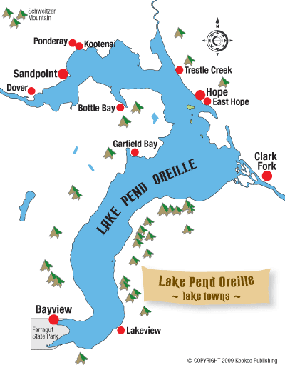
Lake Pend Oreille: The Lake Towns
By Billie Jean Plaster, Chris Bessler and Jane Fritz, with portions excerpted from the book "Wilderness of Water: Legendary Lake Pend Oreille.
A number of small communities dot the shores of Lake Pend Oreille and provide lake access and amenities. Following is a guide to the lake's towns. Scroll down to read more about the lake towns, or click on the town name on the map at right to jump to that town's description.
Sandpoint
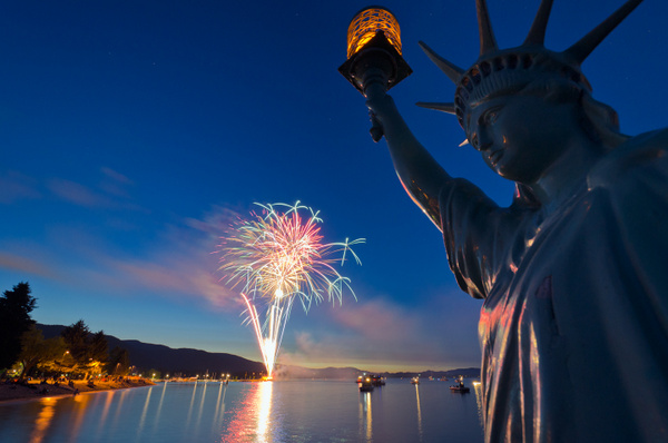
Photo by Ryan McGinty
With about 8,500 souls, Sandpoint is the largest community on the lake and correspondingly offers the most services for lakeside recreation. Both City Beach and Lakeview Park within the city have public docks and picnic facilities. Boaters' services are available at Sandpoint Marina (208-263-3083) at the mouth of Sand Creek, or at the Alpine Shop at 213 Church St. (208-263-5157). Seasonal moorage is available through the City of Sandpoint at City Beach Marina and The Windbag Marina, also at City Beach. Learn more at the
City of Sandpoint's Web site. The city also accepts reservations for visitor moorage. (208-263-3613). Day use moorage is available at City Beach on the east side of the boat launch or at the boardwalk along Sand Creek (not accessible to sailboats). For more information, go to the Super Directory and see
Marinas & Boating Services.
From Sandpoint, Idaho State Highway 200 travels east through Hope and Clark Fork to the Montana Line and is part of the National Scenic Byway program, called the Pend Oreille Scenic Byway. This byway is also part of the Lake Pend Oreille - Kootenai River "Super Side Trip" on the International Selkirk Loop linking Idaho, Washington and British Columbia, Canada.
For its size, Sandpoint has unusually fine dining and shopping, almost all of which is located within walking distance of the water in the downtown. Art galleries and antiques can be found throughout the city, and many businesses display the work of local artists during the town's 12 weeks of Artwalk each summer; Artwalk guides are available at galleries or any participating businesses. Artwalk is just one of many special events held throughout the year. To see more, go to the Events page and notice the special event pages on the left.
You may also want to check out the Bonner County Historical Museum at Lakeview Park on Ella Street, where local history comes alive in life-sized displays and old photographs. The most interesting architectural feature of town is the Cedar Street Bridge Public Market, with retail shops and dining. Just two blocks from all the downtown action is Sandpoint City Beach, the town’s splendid waterfront park, which historically was a traditional Kalispel Indian village called Qp Qepe.
Today City Beach is the site of the Pend Oreille Arts Council’s annual summertime activity, the Arts & Crafts Fair held in mid-August, and a miniature replica of the Statue of Liberty at the end of a concrete pier. The shoreline north of City Beach and the Windbag Marina is home to a multimillion-dollar condominium resort called Seasons at Sandpoint. And north of that is a two-mile-long waterfront pedestrian trail under development, the Pend d’Oreille Bay Trail. City Beach has a paved trail encircling it. Other paved trails connect Sandpoint to Sagle via the Pedestrian Long Bridge, to Dover and to Ponderay. Go to NorthIdahoBikeways.com to learn more.
Lodging on the water in Sandpoint is available at the Edgewater Lodge. For more lodging alternatives, go to the Sandpoint Online Lodging page. The Edgewater Lodge also has a site for RV campers.
The Edgewater Lodge also offers dining on the lake at its on-site restaurant, Trinity at City Beach. Other waterfront dining in Sandpoint is available at Cedar St. Bridge Café, Spuds Rotisserie and Grill, The Loading Dock, Arlo’s Ristorante and Starbucks. To see more, go to the Sandpoint Online Restaurants and Dining page.
For history buffs, Sandpoint was first settled in 1880, when Robert Weeks opened a general store and the Northern Pacific Railroad surveyed the area. The town grew slowly from then on as a railroading, mining and timbering center. Sandpoint is called the “Railroad Funnel” because of the three main lines established here.
For more about Sandpoint, browse the Sandpoint Online Community and Visitor Guide sections, and check out other pages from the Sandpoint Online home page.
Dover
Just west of Sandpoint, the City of Dover is a bedroom community of Sandpoint with about 400 residents; it was incorporated in 1988. Although the town is technically on the Pend Oreille River, many people still consider the waters west of the Long Bridge to be part of the lake all the way to Dover. According to Idaho Fish and Game, however, the official nautical demarcation between the two waterways is the railroad bridge over the lake just east of the Long Bridge.
From Sandpoint, U.S. Highway 2 travels west, coming first to Dover, then on to Laclede, Priest River and Oldtown. This section of U.S. Highway 2 from Sandpoint to the Washington state line is part of the National Scenic Byway system and is called the Panhandle Historic Rivers Passage. This byway is also the southern leg of the International Selkirk Loop linking Idaho, Washington and British Columbia, Canada.
After the Northern Pacific Railroad came through Dover in 1883, the timber industry soon set up shop in 1907. The town, platted in 1908, enjoyed a long history of lumber operations, from the Dover Lumber Company, to the A.C. White Lumber Mill, to the Dover Mill owned by Pack River Management and others until it closed in 1989.
Now the old lumber mill site is home to the City of Dover Public Beach and Park set within the boundaries of the new Dover Bay waterfront community, where’s there’s seasonal and visitor moorage for rent through Waterfront Property Management (208-263-3083). Courtesy tie-ups are also available for people who want to eat at the café or go to the beach for an hour or two. Boat gas is available at the Dover Bay marina dock as are canoe and kayak rentals. The park is sandwiched by the resort and located west of the marina at the end of a narrow sandy stretch of land next to Brown’s Bay Inlet. The Balto Dog Park opened in 2009 and features a boardwalk for diving dogs, fire hydrants and a wash-down area with a solar-heated hose system.
The Dover Bay residential waterfront community got under way in 2005 and transformed the old lumber mill site, with 285 acres and over a mile of shoreline, into a major development with a 274-slip marina, hundreds of homesites, condos, bungalows for vacation rental, common open space, boardwalk, a waterfront village area with a café, market and fitness center.
Dover Bay is now the site of the annual Concerts-on-the-Lawn, free concerts held every Sunday in July, sponsored by Pend Oreille Arts Council. The community also puts on Dover Bay Days in July and participates in other special events such as Sandpoint Winter Carnival. To see more, go to the Events page.
Connecting downtown Sandpoint to Dover is the bike path that is part of the Sandpoint-Dover Community Trail. Paved and flat, it’s and pleasant three-mile walk from downtown Sandpoint to Dover that runs parallel to U.S. Highway 2. That trail leads to more than 9 miles of trails, all open to the public, at Dover Bay, along the water and through natural preserves, and to a beautiful new park, Verwolf Vista Park at the top of Tank Hill, with panoramic views.
Ponderay and Kootenai
These twin towns just east of Sandpoint are part of the greater urban area. Bordering Sandpoint is Ponderay, population of about 700, which has blossomed as a commercial center and is home to Bonner Mall as well as a number of retailers and some big-box discount stores. The Sandpoint Elks Golf Course lies within the Ponderay city limits, and the town is also the gateway to Schweitzer for skiers arriving via Highway 95. There are several motels in Ponderay, along with a number of restaurants. To Ponderay’s east is Kootenai, population of about 500, which has a small commercial district along Highway 200 and encompasses residential areas including Ponder Point and Kootenai Bay. Although there is currently very limited public access to the lake from either of these lakeside towns, the proposed Pend d’Oreille Bay Trail stretches over two miles from Ponderay to Sandpoint and, when it comes to fruition, will provide a premier lakeside park along with the walking and biking trail.
Trestle Creek
About 10 miles east of Sandpoint, only a few miles before you reach the larger town of Hope, is the tiny community of Trestle Creek, built on the rocky delta of its namesake. At Trestle Creek there are both public recreation facilities and private resorts. This is also a popular area for scuba divers since a train derailment into the lake in 1904 left several railcars underwater to explore. Trestle Creek Recreation Area, managed by the U.S. Army Corps of Engineers, is a day-use area only with no fee for public access for swimming and boating.
Located southeast of the mouth of Pack River, this area is named for the original Northern Pacific Railway’s 6,500-foot, curved, wooden trestle built in 1882 that extended from Hawkins Point on the Sunnyside Peninsula to this site across Pack River Bay just west of the creek. At low water, the old pilings of the trestle are still visible. The existing train crossing was built in 1904. Trestle Creek tumbles out of the Cabinet Mountains into the lake here and is an important spawning stream for bull trout and kokanee salmon in the fall.
Hope and East Hope
Photo by Rick Miller
Once a booming railroad town, Hope hugs the hills of the northeastern shore of Lake Pend Oreille, about 14 miles east of Sandpoint. Hope and East Hope, population 79 and 184 (2000 census), respectively, have a colorful history reaching back to 1882 with the construction of the Northern Pacific Railroad. The first inhabitants were Native Americans and then Chinese, who worked on the railroad and flourished in the community until the 1920s.
Hope has some of the best views of the southern arm of the lake and the Monarch Mountains, and is a great place to visit by boat or car. Several public and private boat launches are in the city, including the best deep-water launch on the north end of the lake, the Hope Boat Basin under the bridge at the west end of town. Boaters' services and moorage are available at Hope Marine Services and Holiday Shores/East Hope Marina. Moorage is also available at Kramer Marina and Beyond Hope Resort. For more information, go to the Super Directory and see
Marinas & Boating Services.
Hope also offers some of the nicest restaurants on the water, with tie-ups for boaters at the Floating Restaurant on Ellisport Bay, Beyond Hope Restaurant on the peninsula, and Jorge’s Jetty Bar and Grill at Holiday Shores Marina. To learn more, go to the Hope section in
Sandpoint Online Restaurants and Dining.
Hope also has lodging at the luxurious Pend Oreille Shores Resort on Ellisport Bay with lake swimming, an indoor pool and athletic club and other amenities. See the
Lodging page of Sandpoint Online. Several RV sites are available on the Hope Peninsula at parks like Island View and Beyond Hope. The peninsula is a game preserve, and the white-tailed deer are prolific and easily spotted, especially during evenings. The peninsula is also home to Sam Owen Campground and Recreation Site, maintained by the Forest Service as a fine campground with a boat launch and dock, swimming area, volleyball, hiking trail and interpretive site on David Thompson. Go to the
Sandpoint Online Campground Directory for details.
Clark Fork
Traveling east from Sandpoint along Idaho State Highway 200, the last town you pass through before the Idaho-Montana state line is the small community of Clark Fork. A variety of services are available here, including restaurants, coffee and retail shops, groceries, lodging and RV parks. For more information on accommodations, check the Lodging page.
Incorporated in 1912, this historic community on the Clark Fork River was first an important railroad camp in 1882 with the building of the Northern Pacific Railroad. It also prospered as a center for lead and silver mining in the early 1900s with three major mines – Lawrence, Hope and Whitedelf – whose production activities continued into the 1950s. The area around Clark Fork also was timbered with enormous, old-growth trees, and so logging became another prominent industry here with a series of sawmills built, beginning in 1891. The town still has the flavor of its early beginnings, and descendents of some of the original pioneer families still live here. The town’s traditional July Fourth holiday celebration becomes a sort of reunion for anyone who has ever lived or worked in Clark Fork and is the centerpiece of the community’s yearly events.
Clark Fork has two public parks, one with a ball field north of town, and the other south of the highway. The latter is a relatively quiet place for a picnic with a table shaded by old willow trees. It’s located off Railroad Avenue adjacent to the railroad tracks. East of the town of Clark Fork, up Antelope Mountain, is a picturesque little lake that is designated as Family Fishing Waters, one of six in Bonner County.
Named for Captain William Clark of the Lewis and Clark Corps of Discovery, the “Clark’s Fork of the Columbia River” flows for more than 400 miles through western Montana on its way to Lake Pend Oreille. Most of the shoreline on either side of the river east from Clark Fork to the state line is privately owned. Colby Landing is the closest access point to fish the river from the town of Clark Fork, about 1.75 miles from the bridge. Traveling east, there are only two public access points on the river before reaching the Cabinet Gorge Dam, a hydroelectric project. The Clark Fork Access Site is the newest one, found on the Idaho portion of the river on the north bank, off Idaho State Highway 200. Derr Creek Property is a wetland and wildlife viewing area along Derr Creek, southeast of the town of Clark Fork on the south side of the river.
West of Clark Fork, the marshes and wetlands around Denton Slough and the Clark Fork Delta are part of the Lake Pend Oreille and Clark Fork Wildlife Management Areas and home to a tremendous diversity of waterfowl, fish-eating birds and mammals.
The Clark Fork Delta is a paddler’s paradise. There are sloughs, channels, islands and backwaters to explore where you literally can get lost. Launch sites are at Johnson Creek Access Area, Denton Slough or the Clark Fork Drift Yard boat launch, commonly used by fishermen and waterfowl hunters.
From October through June, fish can be seen at the Cabinet Gorge Fish Hatchery, built to augment the wild kokanee population in Lake Pend Oreille. An aging fish hatchery on Spring Creek managed by Idaho Fish and Game that raised several species of native trout between the 1930s and 1990s is being revitalized for kokanee spawning, a project of the volunteer-directed Lake Pend Oreille Idaho Club..
Bayview
At the tip of the lake's south arm is Bayview on Scenic Bay next door to Farragut State Park, the gateway for Lake Pend Oreille for those approaching from the Spokane-Coeur d’Alene area. In fact it was Spokane entrepreneurs who built it as a resort community, welcoming its first permanent residents in 1910. Situated in a scenic fjord-like inlet, Bayview is a haven for boaters with numerous marinas, some of them with courtesy docks for customers, including Boileau’s Resort & Marina, MacDonald's Hudson Bay Resort, Scenic Bay Marina, Vista Bay Marina and Harbor View Marina. The Bitter End Marina caters to sailboaters and has a club house for their use. This area is a sailor’s heaven whether soloing or joining a regatta of boats from the Lake Pend Oreille Yacht Club out of Bayview. For more information, go to the Super Directory and see
Marinas & Boating Services.
A public boat launch in the center of town has limited moorage as well.
This lakeside community is home to hundreds of sailboats, and you’ll see a lot of float homes and houseboats moored in the marinas, too. They have been a part of the Bayview experience for generations. This is one of the most popular boating and sailing areas on the lake.
The residents of Bayview host a major annual event that draws crowds of tourists from around the region – Bayview Daze. It’s a community celebration that happens around July Fourth and culminates in a spectacular fireworks display over the water.
Dining on the lake is available at Buttonhook Inn and The Floating Patio at Boileau's Resort & Marina for dinner and Captain’s Wheel for lunch and dinner daily plus breakfast Thursdays through Sundays. Just off the water in town is Ralph’s Coffee House for breakfast and lunch, espresso and ice cream; and Terry’s Café for breakfast and lunch, featuring great burgers and such.
Bayview has its own colorful history. The town began in 1880 when early settlers used the facilities at Steamboat Landing around the bend in Idlewilde Bay. Mines and lime quarries along the lake brought more activity. A cement industry flourished in the area in the early decades of the 20th century, and lime was shipped first by barge north to railheads at Hope and Sandpoint, and then directly by rail to Spokane. You can view the ruins of the kilns from Scenic Bay Marina.
Bayview then settled into a little resort town and quiet residential area. That changed with World War II in 1942, however, when the Farragut Naval Training Station was built on more than 4,000 acres surrounding the bay; tens of thousands of recruits subsequently passed through Farragut during the war years. The Navy still has an acoustic research detachment in Bayview. Most of the base was turned over to the State of Idaho, and is now Farragut State Park.
Farragut is one of the state's finest parks in a dramatic natural setting and features more than 40 miles of trails for hikers and bikers to explore, including more than 20 miles also open to equestrian use; numerous campsites; a swimming beach; a museum and historic brig; disc golf course; volleyball area and playground; and ample boating facilities. At the head of this bay and around a small peninsula lies Buttonhook Bay. This protected, southernmost toe point of the lake lies completely within Kootenai County. For more on the history of Farragut, go to the story from Sandpoint Magazine, "
Sailors Ahoy." For more about the state park, go to
this page on the State of Idaho Parks and Recreation site or to the
Sandpoint Online Campground Directory.
Lakeview
Across the lake from Bayview is the tiny community of Lakeview, which sprouted up with the first mine in the area in 1888. By 1892, Lakeview had its own post office and was a steamboat port. Early in the 20th century it was popular summer resort, and it still is a beautiful spot on the lake for summer visitors, making a great stop for boaters and folks touring the Forest Service roads that surround the lake. The county maintains a public dock flanked by private property. Lakeview is surrounded by abandoned limestone mines. Much of the town is situated on a bench well above the lake. Three miles above Lakeview is the Happy Hermit Resort that operates year-round, catering to snowmobile enthusiasts in the winter.
Garfield Bay
This quiet lake community was once the site of a prospective mining town that ended up in scandal. Formerly called Midas, the town was settled in 1909 by Jim McNicholas, who raised money from investors but never produced any dividends. McNicholas was later jailed, and other prospectors who followed him had no luck in finding ore.
Charles Flaty, a homesteader and conductor for Northern Pacific Railroad, renamed the town in admiration for President James Garfield. It has served as a fishing and resort community since the 1950s. In 1976, several men erected what was known as the “White Cross” just above Garfield Bay that could be seen all the way across the lake to Hope. It eventually fell into disrepair but was rebuilt in 1991.
By road, Garfield Bay is 15 miles from Sandpoint and right in the middle of the western shore of the lake, making it an 18-mile boat ride to either Sandpoint or Bayview. It’s also in the middle of the area where the big ones are caught. There are courtesy tie-ups at Garfield Shores Resort and Marina Club, the bay’s only source of boat gas and one of three convenience stores. For more information, go to the Super Directory and see
Marinas & Boating Services. Bonner County maintains a public boat launch, swimming area and campground.
The open cove with its marina, boats and rustic homes offer a delightful repose. The modern campground facilities and adjacent beaches, tucked back and protected at the head of the bay with its pleasant green lawn, make it an ideal family destination with plenty of space for relaxing and playing. It is open year-round. Go to the
Sandpoint Online Campground Directory to learn more. The private marina offers boat slips to rent by the hour or day if you come to have dinner or to stay for a few hours to fish or swim. Looking back from the water, Grouse Mountain is to the west and the next landform south is Grouse Mountain Point before Talache Landing.
Garfield Bay is also a well-protected bay for canoeing or kayaking, although as you round the point toward Green Bay it can get choppy. The shoreline is rocky, but there are some nice stony beaches to enjoy swimming and picnicking. Launching from Garfield Bay it is a one- to three-mile one-way paddle to Green Bay depending on where along the shoreline you land.
Bottle Bay
This small community is wrapped around a well-protected inlet about five miles southeast of Sandpoint as the boat sails and 12 miles as the car drives. The bay started as a seasonal residential area in the 1950s when frontage lots on the east shore of Bottle Bay started selling for $500. This long, bottle-shaped bay still has many of the lake cabins that were built back in the days of commercial whitefish and kokanee fishing. On the west lip of the bay is Sourdough Point, a private residential area that used to be a winter settlement of fishermen who toughed out the harsh, cold months surviving on sourdough bread and smoked fish. Then-commercial fish-processor Bill Zinter built the resort and marina.
Today it is still primarily a residential area, and Bottle Bay Marina and Resort offers a small restaurant, gas, boat launch, moorage, cabins, and canoe, paddle boat and kayak rentals. For more information, go to the Super Directory and see
Marinas & Boating Services.
For the non-aquatic, Bottle Bay makes a fine bicycle destination from Sandpoint, across the Long Bridge pedestrian and bike path that connects up to the quiet Bottle Bay Road. The road parallels the lake shoreline at first with rocky, steep cliffs that edge Gold Hill’s northern slope, then wind down along the water’s edge, followed by more curves and hills, at times as exciting as a roller coaster ride.